• About
    • About Us
    • What We Cover
  • Advertise
    • Advertise
    • Our Advertisers
  • Contact
  • Donate
  • Send News

Oak Ridge Today

  • Home
  • Sign in
  • News
    • Business
    • Community
    • Education
    • Government
    • Health
    • Police and Fire
    • U.S. Department of Energy
    • Weather
  • Sports
    • High School
    • Middle School
    • Recreation
    • Rowing
    • Youth
  • Entertainment
    • Arts
    • Dancing
    • Movies
    • Music
    • Television
    • Theater
  • Premium Content
  • Obituaries
  • Classifieds

Anderson, Roane schools closed Monday; Briceville Highway closed due to ‘slide issues’

Posted at 8:38 pm April 23, 2017
By John Huotari Leave a Comment

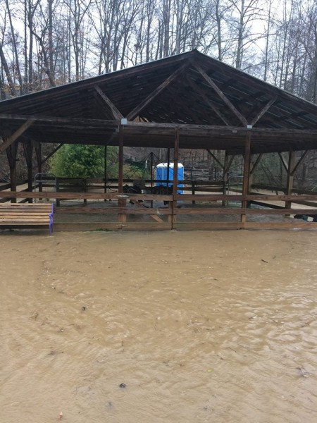
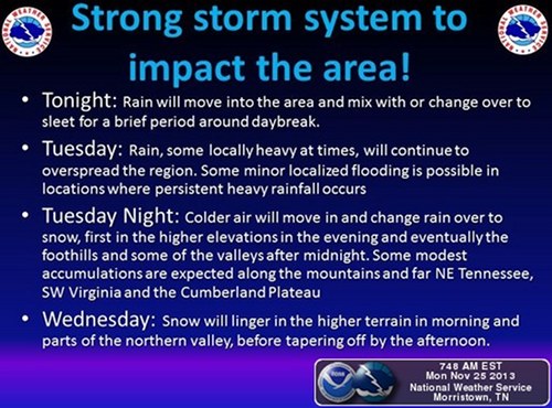
State Route 116 in Anderson County, also known as Briceville Highway, is closed at Hawkins Road due to “slide issues,” the Tennessee Department of Transportation said Sunday. Also Sunday, Anderson County Schools and Roane County Schools both announced they will be closed Monday.

TDOT said traffic on Briceville Highway is being diverted to county roads.

“Use caution in this area,” TDOT said.

Hawkins Road is southwest of Rocky Top (the former Lake City) and northeast of Briceville.

Briceville Highway had earlier been reported to be closed in Briceville due to sinking pavement on Sunday afternoon. [Read more…]

Filed Under: Front Page News, Government, State, Top Stories, Weather Tagged With: Anderson County Schools, Briceville, Briceville Highway, flooded roads, flooding, Hawkins Road, Knox County Schools, Morgan County Schools, National Weather Service, Norris Dam State Park, NWS, rain, Roane County schools, State Route 116, State Route 71, TDOT, Tennessee Department of Transportation

Trees fall, roads flood, driver escapes floodwaters as rains continue

Posted at 7:16 pm April 23, 2017
By John Huotari 2 Comments

Airport-Road-Flooding-Oliver-Springs-Storms-April-22-2017

The driver was reported to have made it out of floodwaters before emergency responders arrived on Saturday afternoon, April 22, 2017, but her black Nissan Altima remained partially submerged on Airport Road near Oliver Springs on Sunday. (Photo by John Huotari/Oak Ridge Today)


Note: This story was last updated at 8 p.m.

Roads flooded and trees fell—sometimes on homes, power lines, and roads—as rain continued to fall in East Tennessee on Sunday. One driver was reported to have escaped from her car in floodwaters on Airport Road near Oliver Springs on Saturday afternoon, but the black Nissan Altima remained partially submerged in the water on Sunday.

There appeared to have been at least 10 reports of fallen trees in Oak Ridge during the severe thunderstorms that started Saturday afternoon and continued with rain showers on Sunday. Most of those trees were reported to have fallen on homes, power lines, across roadways, or on personal property such as an automobile. There were five reports of fallen trees between about 3 and 4:30 p.m. Sunday, including a tree that fell across both lanes of Melton Lake Drive near Calhoun’s restaurant, causing a temporary closure of that two-lane road.

There were more reports of trees that had fallen but not damaged anything.

Large trees are falling due to excess rain, the City of Oak Ridge said Sunday. Electric crews have been out all night, and backup is on the way, the city said, but it may be tomorrow (Monday, April 24) before all power is back.

At various times on Sunday, there were reports of flooding or flood watches across Oak Ridge, including on Vermont Avenue, near Heritage Center (the former K-25 site), on California Avenue, and at Jefferson Avenue and North Jefferson Circle.

There were also reports of trees down and road closures in Clinton. Briceville Highway was reported to be closed in Briceveille due to sinking pavement on Sunday afternoon. Earlier Sunday, State Route 71 in Anderson County was closed for several hours at Norris Dam State Park because trees were blocking the road, according to the Tennessee Department of Transportation.

Some school districts have announced they will be closed Monday. Roane County Schools said it will be closed due to “concerning road conditions throughout the county.” Anderson County Schools said it will be closed because of dangerous conditions with flooded roads and trees being down.

The National Weather Service in Morristown said a record for daily rainfall was set at Knoxville Mcghee Tyson Airport on Sunday. The NWS said 1.89 inches had fallen as of 5 p.m. Sunday, breaking the old record of 1.63 inches in 1977.

[Read more…]

Filed Under: Anderson County, Norris, Oak Ridge, Oliver Springs, Police and Fire, Police and Fire, Slider, Weather Tagged With: Airport Road, Anderson County Schools, Briceville Highway, City of Oak Ridge, Clinton Highway, Clinton Utilities Board, Darryl Kerley, Darwin "T.C." Davis Sports Complex, East Tennessee, fallen trees, flooding, floodwater, Kenneth Morgan, Lookout Avenue, Midway Drive, National Weather Service, Nicholas Jones, Oak Ridge, Oak Ridge Fire Department, Oliver Springs, Oliver Springs High School, Oliver Springs Police Department, rain, road closures, Roane County schools, Sarah Carrie Hunter, State Route 71, Tennessee Department of Transportation, Windrock Road

Emergency workers respond to car crash, fallen trees, flooding

Posted at 10:44 pm April 22, 2017
By John Huotari 4 Comments

Oak-Ridge-Flooding-Oak-Ridge-Turnpike-Illinois-Avenue-April-22-2017-Slider

Floodwaters rose close to road level at the intersection of Oak Ridge Turnpike and Illinois Avenue after heavy rains fell in Oak Ridge on Saturday afternoon and evening, April 22, 2017. (Photo by John Huotari/Oak Ridge Today)


Oak Ridge emergency workers responded to a car crash that injured two people, two fallen trees, and a possible apartment complex evacuation due to flooding during the severe thunderstorms on Saturday.

Heavy rain from the storms led to widespread flooding in Oak Ridge starting late Saturday afternoon. The water appeared to have receded in places a few hours later, or by early Saturday night.

Emergency workers made preparations Saturday evening to possibly evacuate apartments on Royce Circle, where water covered part of the roadway and rose near the first floor of an apartment complex at the northeast end of the circle. The apartments, which are next to Robertsville Road and just east of Willow Brook Elementary School, are in a low-lying area between two creeks that flow down along Jefferson Avenue and intersect with East Fork Poplar Creek, which was swollen with floodwaters on Saturday.

Authorities had made preparations to see how many people lived on the first floor of the Royce Circle apartment complex in case the residents had to be evacuated, Oak Ridge Fire Department Chief Darryl Kerley said. Of the 10 people there, all but one had another place to go, he said. Authorities were watching the water, Kerley said.

“We think it’s receding,” he said Saturday night. [Read more…]

Filed Under: Front Page News, Oak Ridge, Police and Fire, Police and Fire, Slider, Top Stories, Weather Tagged With: crash, Darryl Kerley, East Fork Poplar Creek, Emergency Operations Center, fallen tree, flooding, heavy rain, Oak Ridge Fire Department, Oak Ridge Police Department, Oak Ridge Public Works Department, Oliver Springs Fire Department, power outages, Royce Circle, severe thunderstorms, Y-12 Fire Department

Little Ponderosa Zoo floods; damage unknown, but animals safe, dry

Posted at 3:53 pm March 1, 2017
By Oak Ridge Today Staff Leave a Comment

The Little Ponderosa Zoo in Clinton has flooded. The damage is unknown, but the animals are safe and dry, the zoo said Wednesday afternoon, March 1, 2017. (Photo by Little Ponderosa Zoo)

The Little Ponderosa Zoo in Clinton has flooded. The damage is unknown, but the animals are safe and dry, the zoo said Wednesday afternoon, March 1, 2017. (Photo by Little Ponderosa Zoo)


The Little Ponderosa Zoo in Clinton has flooded. The damage is unknown, but the animals are safe and dry, the zoo said Wednesday afternoon.

“We have been hit with a lot of water today,” The Little Ponderosa Zoo said. “We have been able to keep our animals dry, but the damage to our bridges and buildings like our concession stand is for now unknown. We will know more once the water has receded.”

See The Little Ponderosa Zoo page on Facebook for more information. See a video posted on the zoo’s Facebook page below. [Read more…]

Filed Under: Anderson County, Business, Clinton, Community, Front Page News, Top Stories Tagged With: flooding, Little Ponderosa Zoo

Trees down, power outages, flooding reported in Oak Ridge, Anderson County

Posted at 9:08 am February 24, 2016
By John Huotari Leave a Comment

Nebraska-Avenue-Tree-Down-Feb-24-2016

A tree was down on Nebraska Avenue on Wednesday morning, Feb. 24, 2016. (Photo by Julio Culiat)


Note: This story was last updated at 1:15 p.m.

Officials reported that trees were down across Oak Ridge and Anderson County on Wednesday morning, there were several power outages in Oak Ridge, and flooding was reported at some spots in Anderson County.

The flooding, fallen trees, and power outages were reported after a round of storms came through Wednesday morning.

Crews from the city and county are responding. [Read more…]

Filed Under: Anderson County, Front Page News, Government, Oak Ridge, Oak Ridge, Police and Fire, Slider, Top Stories, Weather, Weather Tagged With: Anderson County, Anderson County Sheriff's Department, City of Oak Ridge, flooding, Mark Lucas, Oak Ridge, Oak Ridge Animal Shelter, Oak Ridge Electric Department, Oak Ridge Public Works Department, power outages, Scott Jackson, storms

NWS: Showers, thunderstorms this afternoon, evening

Posted at 3:28 pm September 11, 2014
By Oak Ridge Today Staff Leave a Comment

Showers and Thunderstorms

Image courtesy National Weather Service in Morristown

Showers and thunderstorms this afternoon and evening could lead to locally heavy rainfall and minor flooding, forecasters said.

Lightning and gusty winds are also possible, according to the National Weather Service in Morristown.

There is a 70 percent chance of thunderstorms this afternoon and tonight near Oak Ridge, with a high of 83, the NWS said.

There is a 60 percent chance of showers on Friday, with a high of 81.

The greatest chance of precipitation in the area today is late this afternoon through midnight, forecasters said.

Filed Under: Weather Tagged With: flooding, lightning, rain, showers, thunderstorms, winds

Haslam announces federal aid for 18 counties

Posted at 10:14 am August 17, 2014
By Oak Ridge Today Staff Leave a Comment

Governor Bill Haslam

Bill Haslam

Counties receive disaster recovery funds for June flooding

NASHVILLE—Tennessee Gov. Bill Haslam on Thursday announced President Obama has declared 18 counties as federal disaster areas as a result of severe weather on June 5-10. State and local governments and electrical utilities spent nearly $10 million in response to and recovery from the wind damage and flash-flooding impacts.

“This federal aid will help our communities in rebuilding and recovery,” Haslam said. “State and local teams worked quickly to survey damage in more than 35 counties to determine the impact of these storms, and we are grateful for this assistance.”

The counties that will have access to federal aid include Anderson, Bledsoe, Carroll, Decatur, Henry, Hickman, Houston, Lawrence, Lewis, Madison, Marion, Maury, McNairy, Moore, Perry, Roane, Sequatchie, and Tipton. They will have access to federal assistance that provides reimbursement for 75 percent of eligible costs. A presidential disaster declaration also includes FEMA’s hazard mitigation grant program on a statewide basis.

Three fatalities were attributed to the severe weather and flooding. Two deaths occurred in Lawrence County and another in Hickman County. [Read more…]

Filed Under: Federal, Government, State, Top Stories, Weather Tagged With: Anderson, Bill Haslam, federal disaster areas, flash flooding, flooding, National Weather Service, President Obama, Roane, severe weather, storms, tornado, wind damage

President declares disaster for Tennessee, including Anderson, Roane

Posted at 12:37 am August 14, 2014
By John Huotari Leave a Comment

Passtime Garage Storm Damage

Passtime Garage on South Main Street in Clinton was damaged by a fast-moving storm and severe winds in early June. (Photo courtesy WYSH Radio/WGAP Radio)

WASHINGTON—The U.S. Department of Homeland Security’s Federal Emergency Management Agency announced Wednesday that federal disaster aid has been made available to the state of Tennessee to supplement state and local recovery efforts in the area affected by severe storms, tornadoes, straight-line winds and flooding from June 5-10.

The action by President Barack Obama makes federal funding available to state and eligible local governments and certain private nonprofit organizations on a cost-sharing basis for emergency work and the repair or replacement of facilities damaged by severe storms, tornadoes, straight-line winds, and flooding in Anderson, Bledsoe, Carroll, Decatur, Henry, Hickman, Houston, Lawrence, Lewis, Madison, Marion, Maury, McNairy, Moore, Perry, Roane, Sequatchie, and Tipton counties, officials said.

Federal funding is also available on a cost-sharing basis for hazard mitigation measures statewide, FEMA said in a press release.

W. Michael Moore has been named as the federal coordinating officer for federal recovery operations in the affected area. Moore said additional designations may be made at a later date if requested by the state and warranted by the results of further damage assessments. [Read more…]

Filed Under: Anderson County, Federal, Government, Roane County, State, Top Stories, Weather Tagged With: Anderson, Barack Obama, Clinton, disaster aid, East Tennessee, federal disaster aid, Federal Emergency Management Agency, FEMA, flooding, Kingston, Oak Ridge, Roane, severe storm, straight-line winds, tornado, tornadoes, U.S. Department of Homeland Security, W. Michael Moore

Tornado watch, severe storms possible Sunday evening

Posted at 6:20 pm July 27, 2014
By Oak Ridge Today Staff Leave a Comment

National Weather Service Severe Weather Threat

Image courtesy of National Weather Service in Morristown.

Note: This story was updated at 6:55 p.m. with a new tornado warning.

A tornado watch is in effect for the northern half of East Tennessee—including Anderson, Knox, and Roane counties—through 8 p.m., and there is a chance of severe thunderstorms near Oak Ridge through midnight, the National Weather Service said.

Update: A tornado warning was issued at 6:26 p.m. for southern Campbell County, Scott County, and northwestern Anderson County. It’s in effect through 7:15 p.m., and it applies to Lake City and Rosedale in Anderson County, as well as LaFollette, Caryville, and Jacksboro in Campbell County, and Huntsville and Oneida in Scott County. (The tornado warning has since been extended to 7:45 p.m.)

Radar showed a severe thunderstorm capable of producing a tornado. The dangerous storm was located over Helenwood, about eight miles south of Oneida, and moving southeast at 35 mph, the NWS said.

People in the affected areas should take cover now, moving to a basement or interior room on the lowest floor of sturdy building. Windows should be avoided. If in a mobile home or outdoors, move to the closest substantial shelter and protect yourself from flying debris. [Read more…]

Filed Under: News, Top Stories, Weather Tagged With: damaging winds, East Tennessee, flooding, heavy rain, large hail, National Weather Service, NWS, Oak Ridge, severe thunderstorms, severe weather, showers, thunderstorms, tornado watch, tornadoes

Forecast: Severe thunderstorms, heavy rain; tornado, flood watches issued

Posted at 3:29 pm April 28, 2014
By Oak Ridge Today Staff Leave a Comment

NWS Severe Thunderstorms, Rain, Wind

Image courtesy National Weather Service in Morristown.


Severe thunderstorms, heavy rain, and flooding are possible in the region starting Monday evening and continuing through Tuesday night, according to the National Weather Service in Morristown.

Isolated tornadoes are possible, mainly across the Cumberland Plateau and southern half of the Tennessee Valley, the Weather Service said. A tornado watch remains in effect until 8 p.m. Monday for southwestern Virginia and East Tennessee. The watch includes Anderson, Blount, Campbell, Knox, Loudon, Morgan, Roane, and Scott counties, among others.

The flood watch is in effect from 8 p.m. today until 8 a.m. Tuesday.

The National Weather Service said its main concerns are the isolated tornadoes, widespread damaging winds that could cause power outages due to fallen trees and power lines, and heavy rainfall producing flash flooding. Large hail is also possible.

The forecast near Oak Ridge calls for a 60 percent chance of heavy rain this afternoon, with a 100 percent chance of severe thunderstorms tonight. [Read more…]

Filed Under: Top Stories, Weather Tagged With: Cumberland Plateau, flash flooding, flood watch, flooding, hail, heavy rain, low-pressure system, National Weather Service, NWS, Oak Ridge, severe thunderstorms, Tennessee Valley, thunderstorms, tornado watch, tornadoes, wind gusts, winds

NWS: Chance of snow Wednesday, sunny Thanksgiving

Posted at 7:04 pm November 25, 2013
By John Huotari Leave a Comment

National Weather Service Storm Warning

The National Weather Service says a strong regional storm system could bring heavy rain, sleet, and snow early this week. (Images courtesy National Weather Service)

The National Weather Service in Morristown is warning of a strong regional storm system that could bring heavy rain, sleet, and snow to East Tennessee and southwest Virginia early this week.

Forecasters said rain will move into the area tonight (Monday night) and could briefly change over to or mix with sleet around daybreak Tuesday. The rain is expected to continue Tuesday, with some minor local flooding possible.

Colder air moving into the region on Tuesday night could change the rain to snow, starting at higher elevations in the evening and working down to the foothills and some valleys after midnight, forecasters said.


[Read more…]

Filed Under: Top Stories, Weather, Weather Tagged With: colder air, East Tennessee, flooding, Morristown, National Weather Service, rain, sleet, snow, southwest Virginia, storm system, Thanksgiving Day

TVA releasing dam water to reduce Tennessee River flooding

Posted at 4:30 pm July 10, 2013
By Oak Ridge Today Staff Leave a Comment

The Tennessee Valley Authority on Wednesday said it is working to move large volumes of water—as much as one million gallons per second in some places—along the Tennessee River system to reduce potentially damaging flooding from record rainfall.

TVA said it prepared for this event by lowering reservoir levels on the main channel of the Tennessee River beginning the last week of June, leaving some areas below normal for this time of year. [Read more…]

Filed Under: Federal, Government, Top Stories Tagged With: Chuck Bach, dams, flooding, rain, rainfall, reservoir, runoff, Tennessee River, Tennessee Valley, Tennessee Valley Authority, TVA, TVA River Operations, water

« Previous Page
Next Page »

Search Oak Ridge Today

Classifieds

Availability of the draft environmental assessment for off-site depleted uranium manufacturing (DOE/EA-2252)

The U.S. Department of Energy (DOE) National Nuclear Security Administration (NNSA) announces the … [Read More...]

Public Notice: NNSA announces no significant impact of Y-12 Development Organization operations at Horizon Center

AVAILABILITY OF THE FINAL ENVIRONMENTAL ASSESSMENT FOR THE OFFSITE HOUSING OF THE Y-12 DEVELOPMENT … [Read More...]

ADFAC seeks contractors for five homes

Aid to Distressed Families of Appalachian Counties (ADFAC) is a non-profit community based agency, … [Read More...]

Recent Posts

  • Anderson County Chamber Headquarters Dedication Set for October 17
  • ORISE announces winners of 2025 Future of Science Awards
  • SL Tennessee Supports New Anderson County Chamber Headquarters
  • ORAU 2025 Pollard Scholarship recipients announced
  • Democratic Womens Club Hosts State Rep. Sam McKenzie
  • Flatwater Tales Storytelling Festival Announces 2025 Storytellers
  • Laser-Engraved Bricks Will Line Walkway of New Chamber Headquarters
  • Democratic Womens Club to Discuss Climate Change, Energy and Policy
  • Estate Jewelry Show at Karens Jewelers Features Celebrity Jewelry
  • Keri Cagle named new ORAU senior vice president and ORISE director

Recent Comments

  • Raymond Mitchell on City manager’s ‘State of the City’ canceled due to weather
  • Raymond Mitchell on City manager’s ‘State of the City’ canceled due to weather
  • Mysti M Desilva on Crews clearing roads, repairing water line breaks
  • Mel Schuster on Crews clearing roads, repairing water line breaks
  • Cecil King on Crews clearing roads, repairing water line breaks
  • Rick Morrow on Roads, schools, businesses closed after heavy snow
  • Diana lively on Free community Thanksgiving Dinner on Nov. 25
  • Anne Garcia on School bus driver arrested following alleged assault on elementary student
  • Raymond Dickover on Blockhouse Valley Recycling Center now open 6 days per week
  • Mike Mahathy on School bus driver arrested following alleged assault on elementary student

Copyright © 2025 Oak Ridge Today