• About
    • About Us
    • What We Cover
  • Advertise
    • Advertise
    • Our Advertisers
  • Contact
  • Donate
  • Send News
  • Subscribe

Oak Ridge Today

  • Home
  • Sign in
  • News
    • Business
    • Community
    • Education
    • Government
    • Health
    • Police and Fire
    • U.S. Department of Energy
    • Weather
  • Sports
    • High School
    • Middle School
    • Recreation
    • Rowing
    • Youth
  • Entertainment
    • Arts
    • Dancing
    • Movies
    • Music
    • Television
    • Theater
  • Premium Content
  • Obituaries
  • Classifieds


Latest on Hurricane Irma: Expected impacts in Tennessee Valley

Posted at 7:32 pm September 9, 2017
By John Huotari Leave a Comment

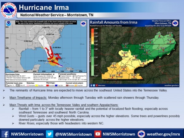
The forecast for Hurricane Irma and its expected impacts across East Tennessee, southwest Virginia, and southwest North Carolina as of Saturday afternoon, Sept. 9, 2017. (Image courtesy National Weather Service in Morristown)

The forecast for Hurricane Irma and its expected impacts across East Tennessee, southwest Virginia, and southwest North Carolina as of Saturday afternoon, Sept. 9, 2017. (Image courtesy National Weather Service in Morristown)


The National Weather Service in Morristown on Saturday afternoon released updated information on the expected impacts of Hurricane Irma in East Tennessee, southwest Virginia, and southwest North Carolina.

The strong winds and outer rain bands of the hurricane, which has weakened to a Category 3 storm from an earlier Category 5, started hitting the Florida Keys on Saturday as officials warned of a potentially deadly storm surge in southern Florida.

The storm track appeared to have moved farther west than originally forecast, and Hurricane Irma was expected to now have a bigger impact on central and western Florida as it moved up the peninsula.

The remnants of the storm, which had sustained winds of 125 mph on Saturday afternoon, are expected to move across the southeast United States and into the Tennessee Valley, possibly starting Monday afternoon and continuing through Tuesday, with scattered showers through Thursday. [Read more…]
Filed Under: Top Stories, Weather Tagged With: Anderson County, Florida, Hurricane Irma, National Hurricane Center, National Weather Service, rain, rising rivers, Tennessee Valley, wind gusts

NWS: Hurricane Irma could lead to rain, wind, rising rivers in region

Posted at 10:04 am September 8, 2017
By John Huotari Leave a Comment

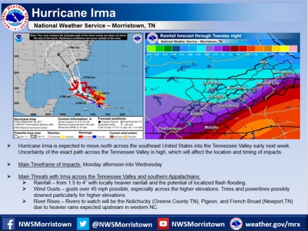
Here is the latest on Hurricane Irma and its impacts across East Tennessee from the National Weather Service in Morristown, Tennessee. (Image courtesy NWS)

Here is the latest on Hurricane Irma and its possible impacts across East Tennessee next week from the National Weather Service in Morristown, Tennessee. (Image courtesy NWS)


Hurricane Irma is expected to move north across the southeast United States into the Tennessee Valley early next week, and it could bring rain and wind gusts, and cause some rivers to rise, according to the National Weather Service in Morristown, Tennessee.

Hurricane Irma, which has been downgraded to a Category 4 storm, could hit the Florida Keys by late Saturday and heavily populated areas of South Florida on Sunday morning. The deadly hurricane pushed through the Bahamas and onto Cuba on Friday, and it has already caused destruction across the Caribbean.

Current forecasts show Hurricane Irma traveling up the center of the Florida peninsula before hitting Georgia, Alabama, and Tennessee, among other states.

The National Weather Service in Morristown said the exact path across the Tennessee Valley is uncertain, which will affect the location and timing of the expected impacts. [Read more…]

Filed Under: Top Stories, Weather Tagged With: Hurricane Irma, National Weather Service, rain, southern Appalachians, Tennessee, Tennessee Valley, tropical depression, wind gusts

Forecast: Severe thunderstorms, heavy rain; tornado, flood watches issued

Posted at 3:29 pm April 28, 2014
By Oak Ridge Today Staff Leave a Comment

NWS Severe Thunderstorms, Rain, Wind

Image courtesy National Weather Service in Morristown.


Severe thunderstorms, heavy rain, and flooding are possible in the region starting Monday evening and continuing through Tuesday night, according to the National Weather Service in Morristown.

Isolated tornadoes are possible, mainly across the Cumberland Plateau and southern half of the Tennessee Valley, the Weather Service said. A tornado watch remains in effect until 8 p.m. Monday for southwestern Virginia and East Tennessee. The watch includes Anderson, Blount, Campbell, Knox, Loudon, Morgan, Roane, and Scott counties, among others.

The flood watch is in effect from 8 p.m. today until 8 a.m. Tuesday.

The National Weather Service said its main concerns are the isolated tornadoes, widespread damaging winds that could cause power outages due to fallen trees and power lines, and heavy rainfall producing flash flooding. Large hail is also possible.

The forecast near Oak Ridge calls for a 60 percent chance of heavy rain this afternoon, with a 100 percent chance of severe thunderstorms tonight. [Read more…]

Filed Under: Top Stories, Weather Tagged With: Cumberland Plateau, flash flooding, flood watch, flooding, hail, heavy rain, low-pressure system, National Weather Service, NWS, Oak Ridge, severe thunderstorms, Tennessee Valley, thunderstorms, tornado watch, tornadoes, wind gusts, winds

Search Oak Ridge Today

Classifieds

Public Notice: NNSA announces no significant impact of Y-12 Development Organization operations at Horizon Center

AVAILABILITY OF THE FINAL ENVIRONMENTAL ASSESSMENT FOR THE OFFSITE HOUSING OF THE Y-12 DEVELOPMENT … [Read More...]

ADFAC seeks contractors for five homes

Aid to Distressed Families of Appalachian Counties (ADFAC) is a non-profit community based agency, … [Read More...]

Public notice: Draft environmental assessment for Y-12 Development Organization at Horizon Center

AVAILABILITY OF THE DRAFT ENVIRONMENTAL ASSESSMENT FOR THE OFFSITE HOUSING OF THE Y-12 DEVELOPMENT … [Read More...]

Recent Posts

  • ORNL scientist to lead project studying permafrost thaw, climate processes in Alaska
  • Community Band has Memorial Day concert
  • Outdoor Pool closed Sunday due to weather
  • Outdoor pool to re-open Friday
  • Children’s Museum to celebrate 50 years with free admission
  • Flatwater Tales Storytelling Festival returning to Oak Ridge
  • City brush pickup continues
  • ORAU employees donate more than 300 pounds of toys and household items to Holiday Bureau
  • Oak Ridge hosting three regattas this month
  • Learn about alternatives to death penalty
A Twitter List by OakRidgeToday

Recent Comments

  • John Huotari on Power to TRISO at Horizon could cost $13 million
  • John Huotari on Lawsuit seeks 2020 election audit, voting machine restriction
  • Peter Scheffler on Lawsuit seeks 2020 election audit, voting machine restriction
  • Peter Scheffler on Power to TRISO at Horizon could cost $13 million
  • Matt Bailey on Dodson also wants to serve as mayor pro tem
  • Mark Caldwell on Dodson also wants to serve as mayor pro tem
  • Matt Bailey on Dodson also wants to serve as mayor pro tem
  • Mark Caldwell on Dodson also wants to serve as mayor pro tem
  • Matt Bailey on Dodson also wants to serve as mayor pro tem
  • Tracy Powers on Planning Commission to consider Main Street apartments, plan revisions

About Us

About Oak Ridge Today
What We Cover

How To

Advertise
Subscribe

Contact Us

Contact Oak Ridge Today

Copyright © 2023 Oak Ridge Today