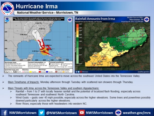
The forecast for Hurricane Irma and its expected impacts across East Tennessee, southwest Virginia, and southwest North Carolina as of Saturday afternoon, Sept. 9, 2017. (Image courtesy National Weather Service in Morristown)
The National Weather Service in Morristown on Saturday afternoon released updated information on the expected impacts of Hurricane Irma in East Tennessee, southwest Virginia, and southwest North Carolina.
The strong winds and outer rain bands of the hurricane, which has weakened to a Category 3 storm from an earlier Category 5, started hitting the Florida Keys on Saturday as officials warned of a potentially deadly storm surge in southern Florida.
The storm track appeared to have moved farther west than originally forecast, and Hurricane Irma was expected to now have a bigger impact on central and western Florida as it moved up the peninsula.
The remnants of the storm, which had sustained winds of 125 mph on Saturday afternoon, are expected to move across the southeast United States and into the Tennessee Valley, possibly starting Monday afternoon and continuing through Tuesday, with scattered showers through Thursday.
The main threats in the Tennessee Valley and southern Appalachians are rain, wind gusts, and rising rivers, especially along those rivers with headwaters in western North Carolina, according to the National Weather Service.
Wind gusts of more than 45 mph are possible, especially at higher elevations, the NWS said. Some trees and power lines could be knocked down, particularly across higher elevations.
Rainfall of one to three inches is possible, with some locally heavier rainfall excepted and the possibility of local flash flooding, especially across southeast Tennessee and southwest North Carolina.
About 1.5 inches of rain is possible in Anderson County, according to Weather Service information.
The National Weather Service said rain associated with Hurricane Irma was expected to start affecting southern Florida overnight Friday and continuing Saturday night into Sunday. Irma will produce very heavy rain and inland flooding, the Weather Service said. Up to 20 inches of rain may fall over the eastern Florida peninsula and upper Florida Keys by Monday. Irma will also bring heavy rain to much of Georgia, South Carolina, and western North Carolina by Monday.
CNN reported that Irma slowly began turning from Cuba’s northern coast up into the Florida Strait on Saturday afternoon, according to the National Hurricane Center. The storm is expected to strengthen again and remain a powerful hurricane when it reaches Florida, CNN said.
Irma’s eye was due to strike part of the Florida Keys on Sunday morning before driving up the state’s southwestern coast Sunday afternoon, according to the hurricane center, CNN reported.
More information will be added as it becomes available.
Do you appreciate this story or our work in general? If so, please consider a monthly subscription to Oak Ridge Today. See our Subscribe page here. Thank you for reading Oak Ridge Today.
Copyright 2016 Oak Ridge Today. All rights reserved. This material may not be published, broadcast, rewritten, or redistributed.
Leave a Reply