• About
    • About Us
    • What We Cover
  • Advertise
    • Advertise
    • Our Advertisers
  • Contact
  • Donate
  • Send News

Oak Ridge Today

  • Home
  • Sign in
  • News
    • Business
    • Community
    • Education
    • Government
    • Health
    • Police and Fire
    • U.S. Department of Energy
    • Weather
  • Sports
    • High School
    • Middle School
    • Recreation
    • Rowing
    • Youth
  • Entertainment
    • Arts
    • Dancing
    • Movies
    • Music
    • Television
    • Theater
  • Premium Content
  • Obituaries
  • Classifieds

Arctic cold expected, starting Saturday night through at least mid-week

Posted at 10:37 pm December 30, 2017
By John Huotari Leave a Comment

Bitterly cold air with prolonged sub-freezing temperatures are expected early next week. From Saturday night, Dec. 30, 2017, through at least mid-week next week, temperatures will be at or below freezing across much of the area. (Image courtesy National Weather Service in Morristown)

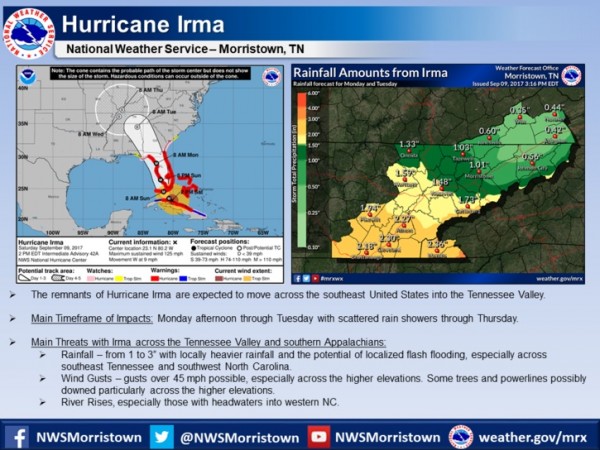
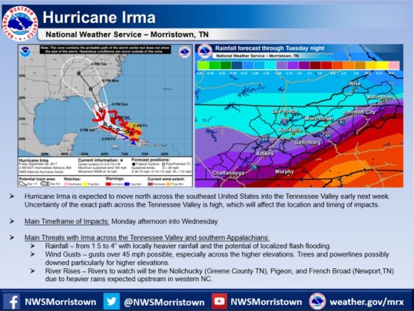
Bitterly cold air with prolonged sub-freezing temperatures is expected early this week. From Saturday night, Dec. 30, 2017, through at least mid-week next week, temperatures will be at or below freezing across much of the area. (Image courtesy National Weather Service in Morristown)


Bitterly cold air with prolonged sub-freezing temperatures is expected early this week, according to the National Weather Service in Morristown.

From Saturday night, December 30, through at least mid-week this week, temperatures will be at or below freezing across much of the area, the National Weather Service said.

The forecast in Oak Ridge calls for a low of 18 degrees Fahrenheit on Saturday night, a high of 30 on Sunday, a low of 15 on Sunday night, a high of 25 on Monday, and a low of 9 on Monday night. The high on Tuesday is forecast at 29. [Read more…]

Filed Under: Front Page News, Slider, Weather, Weather Tagged With: below freezing, bitterly cold air, cold air, cold weather, extreme cold, forecast, National Weather Service, Oak Ridge, sub-freezing temperatures, temperatures

NWS: Colder than normal temps forecast, bitter cold expected later

Posted at 11:31 am December 27, 2017
By John Huotari Leave a Comment

Bitterly cold air is on the way this weekend. Temperatures 10 to 20 degrees below normal and dangerously low wind chills are expected, especially across the higher elevations. Remember to dress warmly in layers, provide shelter for pets and animals, and take precautions around your home or business to avoid frozen pipes. (Image courtesy National Weather Service in Morristown)

Bitterly cold air is on the way this weekend, according to the National Weather Service in Morristown. Temperatures 10 to 20 degrees below normal and dangerously low wind chills are expected, especially across the higher elevations. Remember to dress warmly in layers, provide shelter for pets and animals, and take precautions around your home or business to avoid frozen pipes. (Image courtesy National Weather Service in Morristown)


High temperatures today will be about 10 degrees below normal, and bitterly cold air is on the way this weekend, according to the National Weather Service in Morristown.

Lows in the area around Clinton and Oak Ridge are forecast to be between about 16 and 18 degrees Fahrenheit today (Wednesday, December 27).

Highs are forecast between 34 and 36, with mostly sunny skies today and mostly clear skies tonight.

Temperatures are expected to remain cold this week, with some slight warming on Thursday and more Friday, with colder weather again on Saturday and Sunday and a slight chance of snow on Sunday. [Read more…]

Filed Under: Front Page News, Slider, Weather, Weather Tagged With: bitterly cold air, cold air, hazardous weather outlook, National Weather Service, snow, temperatures

Latest on Hurricane Irma: Expected impacts in Tennessee Valley

Posted at 7:32 pm September 9, 2017
By John Huotari Leave a Comment

The forecast for Hurricane Irma and its expected impacts across East Tennessee, southwest Virginia, and southwest North Carolina as of Saturday afternoon, Sept. 9, 2017. (Image courtesy National Weather Service in Morristown)

The forecast for Hurricane Irma and its expected impacts across East Tennessee, southwest Virginia, and southwest North Carolina as of Saturday afternoon, Sept. 9, 2017. (Image courtesy National Weather Service in Morristown)


The National Weather Service in Morristown on Saturday afternoon released updated information on the expected impacts of Hurricane Irma in East Tennessee, southwest Virginia, and southwest North Carolina.

The strong winds and outer rain bands of the hurricane, which has weakened to a Category 3 storm from an earlier Category 5, started hitting the Florida Keys on Saturday as officials warned of a potentially deadly storm surge in southern Florida.

The storm track appeared to have moved farther west than originally forecast, and Hurricane Irma was expected to now have a bigger impact on central and western Florida as it moved up the peninsula.

The remnants of the storm, which had sustained winds of 125 mph on Saturday afternoon, are expected to move across the southeast United States and into the Tennessee Valley, possibly starting Monday afternoon and continuing through Tuesday, with scattered showers through Thursday. [Read more…]

Filed Under: Top Stories, Weather Tagged With: Anderson County, Florida, Hurricane Irma, National Hurricane Center, National Weather Service, rain, rising rivers, Tennessee Valley, wind gusts

NWS: Hurricane Irma could lead to rain, wind, rising rivers in region

Posted at 10:04 am September 8, 2017
By John Huotari Leave a Comment

Here is the latest on Hurricane Irma and its impacts across East Tennessee from the National Weather Service in Morristown, Tennessee. (Image courtesy NWS)

Here is the latest on Hurricane Irma and its possible impacts across East Tennessee next week from the National Weather Service in Morristown, Tennessee. (Image courtesy NWS)


Hurricane Irma is expected to move north across the southeast United States into the Tennessee Valley early next week, and it could bring rain and wind gusts, and cause some rivers to rise, according to the National Weather Service in Morristown, Tennessee.

Hurricane Irma, which has been downgraded to a Category 4 storm, could hit the Florida Keys by late Saturday and heavily populated areas of South Florida on Sunday morning. The deadly hurricane pushed through the Bahamas and onto Cuba on Friday, and it has already caused destruction across the Caribbean.

Current forecasts show Hurricane Irma traveling up the center of the Florida peninsula before hitting Georgia, Alabama, and Tennessee, among other states.

The National Weather Service in Morristown said the exact path across the Tennessee Valley is uncertain, which will affect the location and timing of the expected impacts. [Read more…]

Filed Under: Top Stories, Weather Tagged With: Hurricane Irma, National Weather Service, rain, southern Appalachians, Tennessee, Tennessee Valley, tropical depression, wind gusts

See solar eclipse path maps by NASA, National Weather Service, Washington Post

Posted at 11:53 am July 30, 2017
By John Huotari Leave a Comment

Image courtesy National Weather Service in Morristown

Image courtesy National Weather Service in Morristown


On Monday, August 21, a total solar eclipse will blot out the sun starting at 2:31 p.m. for viewers in areas within an hour’s drive of Oak Ridge.

The 70-mile-wide path of totality will extend from Oregon to South Carolina, passing through Nashville, Murfreesboro, Sparta, Cookeville, Crossville, Sweetwater, Athens, and Clingman’s Dome, contributor Carolyn Krause wrote in this story.

The National Weather Service in Morristown has published a map showing the eclipse path and showing the duration of the total solar eclipse in parts of East Tennessee. See that map above. Many locations will see more than two minutes and 30 seconds of totality, the Weather Service said.

Another map, which was published by the Washington Post, is interactive and allows you to follow the path of the solar eclipse across the United States from Oregon to South Carolina, with details about points along the way, including Nashville and the Great Smoky Mountains National Park. See that Washington Post map here. [Read more…]

Filed Under: Federal, Front Page News, Government, Top Stories, Weather Tagged With: Carolyn Krause, NASA, National Weather Service, Oak Ridge, path of totality, solar eclipse, total solar eclipse, Washington Post

Total solar eclipse Aug. 21 in Oak Ridge area path

Posted at 7:01 pm July 29, 2017
By Carolyn Krause Leave a Comment

The path of totality for the solar eclipse in the United States on Aug. 21, 2017. (Submitted photo)

The path of totality for the solar eclipse in the United States on Aug. 21, 2017. (Submitted photo)


By Carolyn Krause

Note: This story was updated at 12 p.m. July 30.

On Monday, August 21, a total solar eclipse will blot out the sun starting at 2:31 p.m. for viewers in areas within an hour’s drive of Oak Ridge.

The 70-mile-wide path of totality will extend from Oregon to South Carolina, passing through Nashville, Murfreesboro, Sparta, Cookeville, Crossville, Sweetwater, Athens, and Clingman’s Dome. Oak Ridge will not quite be in the path of totality. The sky over our area will gradually darken starting at 1:03 p.m. It will be plunged into total darkness for up to two minutes and 40 seconds, depending on where you are. The sky should brighten at about 4 p.m.

Image courtesy National Weather Service in Morristown

Image courtesy National Weather Service in Morristown


See a map by NASA and a link to a Washington Post interactive map in this story.

The last time the moon’s shadows in a total solar eclipse crossed our nation from the Pacific to the Atlantic was almost a century ago. On June 8, 1918, the path of totality ran from Washington State to Florida. The next total solar eclipse to cross the U.S. will occur on April 8, 2024. [Read more…]

Filed Under: Community, Education, Front Page News, Top Stories, Weather Tagged With: American Museum of Science and Energy, Chap Percival, Friends of Oak Ridge National Laboratory, Go See the Eclipse, National Park Service, National Weather Service, Oak Ridge Isochronous Observation Network, Oak Ridge National Laboratory, path of totality, Richard D. Smyser Lecture Series, solar eclipse, total solar eclipse, UT-Battelle

Dogwood Jr. Regatta canceled due to increased water flow, unsafe rowing conditions

Posted at 1:08 am April 27, 2017
By Oak Ridge Today Staff Leave a Comment

Dogwood Regatta

This story was updated at 9:55 a.m.

The Dogwood Junior Championship Regatta scheduled for this weekend has been canceled due to increased water flow on Melton Hill Lake and unsafe rowing conditions, the Oak Ridge Rowing Association said on Twitter.

All coaches received a cancellation notice by email through Regatta Central.

“We regretfully announce this cancellation,” the Rowing Association said. “Thank you for all support and understanding that our main goal is to keep rowers safe.” [Read more…]

Filed Under: Front Page News, Rowing, Sports, Top Stories Tagged With: Clinch River, Dogwood Junior Championship Regatta, flooding, heavy rain, Melton hill lake, National Weather Service, Norris Dam, Oak Ridge, Oak Ridge Rowing Association, rain, Tennessee Valley Authority, TVA, unsafe rowing conditions

Oak Ridge received more than 6.3 inches of rain during storms, city says

Posted at 12:29 am April 25, 2017
By John Huotari Leave a Comment

Fallen Tree House April 2017 Storms 1

Oak Ridge received more than 6.3 inches of rain during the storms this past weekend, officials said Monday, April 24, 2017. That amount of rain made the ground extremely soggy and caused large trees to start falling all across the area, the city said. Several homes and cars were damaged, and there were reports of power outages. (Photo courtesy City of Oak Ridge)


Oak Ridge received more than 6.3 inches of rain during the storms this past weekend, officials said.

That amount of rain made the ground extremely soggy and caused large trees to start falling all across the area, the city said. Several homes and cars were damaged, and there were reports of power outages.

Power was nearly 100 percent restored, but the cleanup was still under way Monday afternoon. [Read more…]

Filed Under: Front Page News, Government, Oak Ridge, Oak Ridge, Police and Fire, Top Stories, Weather Tagged With: City of Oak Ridge, downed trees, heavy rainfall, National Weather Service, Oak Ridge, power outages, rain, rainfall totals, storms, Tennessee Valley Authority, TVA

Anderson, Roane schools closed Monday; Briceville Highway closed due to ‘slide issues’

Posted at 8:38 pm April 23, 2017
By John Huotari Leave a Comment

State Route 116 in Anderson County, also known as Briceville Highway, is closed at Hawkins Road due to “slide issues,” the Tennessee Department of Transportation said Sunday. Also Sunday, Anderson County Schools and Roane County Schools both announced they will be closed Monday.

TDOT said traffic on Briceville Highway is being diverted to county roads.

“Use caution in this area,” TDOT said.

Hawkins Road is southwest of Rocky Top (the former Lake City) and northeast of Briceville.

Briceville Highway had earlier been reported to be closed in Briceville due to sinking pavement on Sunday afternoon. [Read more…]

Filed Under: Front Page News, Government, State, Top Stories, Weather Tagged With: Anderson County Schools, Briceville, Briceville Highway, flooded roads, flooding, Hawkins Road, Knox County Schools, Morgan County Schools, National Weather Service, Norris Dam State Park, NWS, rain, Roane County schools, State Route 116, State Route 71, TDOT, Tennessee Department of Transportation

Trees fall, roads flood, driver escapes floodwaters as rains continue

Posted at 7:16 pm April 23, 2017
By John Huotari 2 Comments

Airport-Road-Flooding-Oliver-Springs-Storms-April-22-2017

The driver was reported to have made it out of floodwaters before emergency responders arrived on Saturday afternoon, April 22, 2017, but her black Nissan Altima remained partially submerged on Airport Road near Oliver Springs on Sunday. (Photo by John Huotari/Oak Ridge Today)


Note: This story was last updated at 8 p.m.

Roads flooded and trees fell—sometimes on homes, power lines, and roads—as rain continued to fall in East Tennessee on Sunday. One driver was reported to have escaped from her car in floodwaters on Airport Road near Oliver Springs on Saturday afternoon, but the black Nissan Altima remained partially submerged in the water on Sunday.

There appeared to have been at least 10 reports of fallen trees in Oak Ridge during the severe thunderstorms that started Saturday afternoon and continued with rain showers on Sunday. Most of those trees were reported to have fallen on homes, power lines, across roadways, or on personal property such as an automobile. There were five reports of fallen trees between about 3 and 4:30 p.m. Sunday, including a tree that fell across both lanes of Melton Lake Drive near Calhoun’s restaurant, causing a temporary closure of that two-lane road.

There were more reports of trees that had fallen but not damaged anything.

Large trees are falling due to excess rain, the City of Oak Ridge said Sunday. Electric crews have been out all night, and backup is on the way, the city said, but it may be tomorrow (Monday, April 24) before all power is back.

At various times on Sunday, there were reports of flooding or flood watches across Oak Ridge, including on Vermont Avenue, near Heritage Center (the former K-25 site), on California Avenue, and at Jefferson Avenue and North Jefferson Circle.

There were also reports of trees down and road closures in Clinton. Briceville Highway was reported to be closed in Briceveille due to sinking pavement on Sunday afternoon. Earlier Sunday, State Route 71 in Anderson County was closed for several hours at Norris Dam State Park because trees were blocking the road, according to the Tennessee Department of Transportation.

Some school districts have announced they will be closed Monday. Roane County Schools said it will be closed due to “concerning road conditions throughout the county.” Anderson County Schools said it will be closed because of dangerous conditions with flooded roads and trees being down.

The National Weather Service in Morristown said a record for daily rainfall was set at Knoxville Mcghee Tyson Airport on Sunday. The NWS said 1.89 inches had fallen as of 5 p.m. Sunday, breaking the old record of 1.63 inches in 1977.

[Read more…]

Filed Under: Anderson County, Norris, Oak Ridge, Oliver Springs, Police and Fire, Police and Fire, Slider, Weather Tagged With: Airport Road, Anderson County Schools, Briceville Highway, City of Oak Ridge, Clinton Highway, Clinton Utilities Board, Darryl Kerley, Darwin "T.C." Davis Sports Complex, East Tennessee, fallen trees, flooding, floodwater, Kenneth Morgan, Lookout Avenue, Midway Drive, National Weather Service, Nicholas Jones, Oak Ridge, Oak Ridge Fire Department, Oliver Springs, Oliver Springs High School, Oliver Springs Police Department, rain, road closures, Roane County schools, Sarah Carrie Hunter, State Route 71, Tennessee Department of Transportation, Windrock Road

Snow possible Saturday night

Posted at 8:10 pm March 10, 2017
By John Huotari Leave a Comment

Road crews on Friday prepared roads for possible winter weather, including a potential snow, on Saturday, March 11, 2017. This picture was taken on Wisconsin Avenue on Friday afternoon, March 10. (Photo by Julio Culiat)

Road crews on Friday prepared roads for possible winter weather, including a potential snow, on Saturday, March 11, 2017. This picture was taken on Wisconsin Avenue on Friday afternoon, March 10. (Photo by Julio Culiat)


On Friday, crews prepared roads for possible winter weather this weekend in Oak Ridge and East Tennessee, potentially including snow on Saturday.

The National Weather Service in Morristown said winter will return this weekend with snowfall expected Saturday night across most of the region. Snow accumulations of one to three inches are possible across the Tennessee Valley and Cumberland Plateau, and three to six inches are possible in the Great Smoky Mountains. [Read more…]

Filed Under: Government, Oak Ridge, Slider, Weather, Weather Tagged With: freeze warning, freeze watch, Great Smoky Mountains, National Weather Service, snow, snowfall, Tennessee Valley, winter weather

Multiple weather advisories in effect this afternoon

Posted at 2:04 pm March 1, 2017
By John Huotari Leave a Comment

The threat of severe weather is still in place for today. Be prepared! Make sure you have a way to get weather information and keep up to date on the latest forecast. (Image by National Weather Service in Morristown)

The threat of severe weather is still in place for today. Be prepared! Make sure you have a way to get weather information and keep up to date on the latest forecast. (Image by National Weather Service in Morristown)


There are several weather advisories in effect for Oak Ridge this afternoon (Wednesday, March 1).

The severe thunderstorm warning is in effect until 2:15 p.m.

There is a flood advisory in effect until 4:15 p.m., and a flash flood warning until 4:30 p.m.

A wind advisory remains in effect until midnight. [Read more…]

Filed Under: Top Stories, Weather Tagged With: flood advisory, hazardous weather, National Weather Service, Oak Ridge, severe thunderstorm warning, severe weather, weather advisories, wind advisory

« Previous Page
Next Page »

Search Oak Ridge Today

Classifieds

Availability of the draft environmental assessment for off-site depleted uranium manufacturing (DOE/EA-2252)

The U.S. Department of Energy (DOE) National Nuclear Security Administration (NNSA) announces the … [Read More...]

Public Notice: NNSA announces no significant impact of Y-12 Development Organization operations at Horizon Center

AVAILABILITY OF THE FINAL ENVIRONMENTAL ASSESSMENT FOR THE OFFSITE HOUSING OF THE Y-12 DEVELOPMENT … [Read More...]

ADFAC seeks contractors for five homes

Aid to Distressed Families of Appalachian Counties (ADFAC) is a non-profit community based agency, … [Read More...]

Recent Posts

  • ORAU Annual Giving Campaign raises $91,479 in 2025
  • Alan Forbes named director of Safeguards & Security for ORAU and ORISE
  • ORAU and American Museum of Science and Energy Foundation formalize partnership to advance Manhattan Project 2.0
  • Author and Law Professor Derek W. Black to Speak on Public Education and Democracy
  • Anderson County Chamber Headquarters Dedication Set for October 17
  • ORISE announces winners of 2025 Future of Science Awards
  • SL Tennessee Supports New Anderson County Chamber Headquarters
  • ORAU 2025 Pollard Scholarship recipients announced
  • Democratic Women’s Club Hosts State Rep. Sam McKenzie
  • Flatwater Tales Storytelling Festival Announces 2025 Storytellers

Recent Comments

  • Eric Wilson on Guest column: Former superintendent rebuts Baughn’s school safety allegations
  • Eric Wilson on Guest column: Former superintendent rebuts Baughn’s school safety allegations
  • Raymond Mitchell on City manager’s ‘State of the City’ canceled due to weather
  • Raymond Mitchell on City manager’s ‘State of the City’ canceled due to weather
  • Mysti M Desilva on Crews clearing roads, repairing water line breaks
  • Mel Schuster on Crews clearing roads, repairing water line breaks
  • Cecil King on Crews clearing roads, repairing water line breaks
  • Rick Morrow on Roads, schools, businesses closed after heavy snow
  • Diana lively on Free community Thanksgiving Dinner on Nov. 25
  • Anne Garcia on School bus driver arrested following alleged assault on elementary student

Copyright © 2026 Oak Ridge Today