• About
    • About Us
    • What We Cover
  • Advertise
    • Advertise
    • Our Advertisers
  • Contact
  • Donate
  • Send News

Oak Ridge Today

  • Home
  • Sign in
  • News
    • Business
    • Community
    • Education
    • Government
    • Health
    • Police and Fire
    • U.S. Department of Energy
    • Weather
  • Sports
    • High School
    • Middle School
    • Recreation
    • Rowing
    • Youth
  • Entertainment
    • Arts
    • Dancing
    • Movies
    • Music
    • Television
    • Theater
  • Premium Content
  • Obituaries
  • Classifieds

Updated: Winter storm warning in effect; snow, sleet, freezing rain possible

Posted at 11:51 am February 15, 2015
By John Huotari Leave a Comment

Ice Accumulation

Image courtesy National Weather Service in Morristown


Note: This story was updated at 8:32 a.m. Feb. 16.

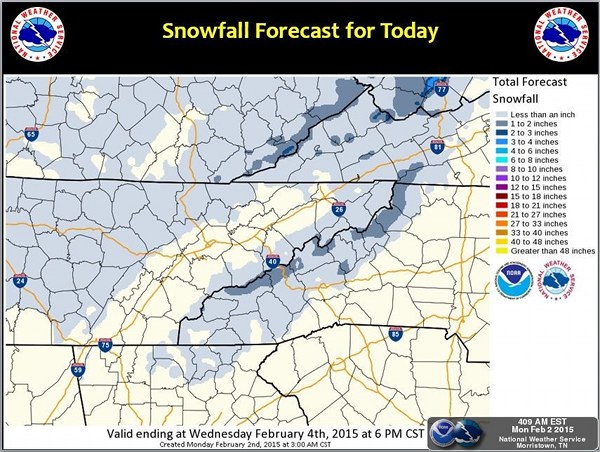
A winter storm warning is in effect in parts of East Tennessee—including Anderson, Knox, Loudon, and Roane counties—and there could be some snow this morning, possibly mixed with sleet, forecasters said. The precipitation could change to a mix of mostly freezing rain and sleet during the day, according to the National Weather Service in Morristown. It could change back to sleet or snow before tapering off.

The NWS said snow and sleet accumulations of one to four inches are possible, and total ice accumulations of a quarter to a half inch are possible.

The winter storm warning area includes Clinton and Oak Ridge, as well as Kingston and Knoxville. It also includes Jefferson, Grainger, and Union counties, and northwest Blount and north Sevier counties. The storm warning is in effect from 7 a.m. Monday to 7 a.m. Tuesday. [Read more…]

Filed Under: Front Page News, Top Stories, Weather Tagged With: cold temperatures, East Tennessee, forecast, freezing rain, hazardous weather, ice, ice accumulation, National Weather Service, NWS, Oak Ridge, sleet, snow, storm warning, Tennessee Valley, wind chill, winter storm, winter storm warning

Dangerously cold wind chills through Sunday morning; snow possible this week

Posted at 2:20 am February 15, 2015
By John Huotari Leave a Comment

Dangerously Cold Wind Chills

Image courtesy National Weather Service in Morristown


Dangerously cold wind chills could drop to between 0 and -10 degrees Fahrenheit in the Tennessee Valley tonight through Sunday morning and even lower, between -10 and -25, in the mountains, forecasters said. And there is a chance of snow near Oak Ridge this week.

Those not dressed appropriately overnight could be susceptible to hypothermia or frostbite. Exposed pipes may freeze, and the cold poses a threat to outdoor pets and livestock, according to the National Weather Service in Morristown.

The NWS said exposed pipes should be insulated or covered, and pets and livestock should be brought in or provided shelter. Forecasters also recommended checking on the elderly or those without sufficient heat. [Read more…]

Filed Under: Front Page News, Top Stories, Weather Tagged With: arctic air, dangerously cold, forecast, frostbite, hypothermia, National Weather Service, NWS, Oak Ridge, snow, temperature, wind, wind chill, winter weather

Forecast: Flurries possible this afternoon

Posted at 12:21 pm February 12, 2015
By John Huotari Leave a Comment

Weather forecasters are calling for a chance of flurries before 3 p.m. Thursday near Oak Ridge. There were already some flurries around noon Thursday.

The temperature is excepted to fall to about 32 degrees by 5 p.m., and the low tonight is forecast at around 16.

The National Weather Service in Morristown issued a special weather statement at 10:26 a.m. Thursday that said an upper-level trough of low pressure will build southeast across the southern Appalachians on Thursday, bringing colder air and just enough moist air to produce some precipitation. [Read more…]

Filed Under: Top Stories, Weather Tagged With: Appalachia, flurries, National Weather Service, snow, snow showers, weather forecast, weather statement

Light snow falling in Oak Ridge

Posted at 11:24 am February 2, 2015
By John Huotari Leave a Comment

Snowfall Forecast Feb. 2, 2015

Images courtesy National Weather Service in Morristown


A light snow fell in Oak Ridge on Monday morning, and the forecast called for a 30 percent chance of snow showers, mainly before 2 p.m.

The forecast near Oak Ridge calls for mostly cloudy skies, with a steady temperature around 34, and a northwest wind of 10 to 15 mph, with gusts as high as 30 mph.

The snowfall was expected to be concentrated mainly in the higher elevations. [Read more…]

Filed Under: Front Page News, Top Stories, Weather Tagged With: cold front, forecast, National Weather Service, Oak Ridge, snow, snow showers

Snow dusts Oak Ridge; Anderson, Roane schools closed

Posted at 9:32 am January 27, 2015
By John Huotari Leave a Comment

Oak Ridge Snow January 27, 2015

A light layer of snow dusted Oak Ridge on Tuesday morning. (Photo by Sarah Johnson)


A light layer of snow dusted Oak Ridge on Tuesday morning, and schools were closed in Anderson and Roane counties.

The Anderson County Schools’ Central Office was following its bad weather procedures. The Roane County Schools’ Central Office opened one hour late.

Oak Ridge Schools opened on time.

Clinton City Schools reported that roads were clear in Clinton—”and school buildings are warm”—and schools would open on time. [Read more…]

Filed Under: Education, K-12, Top Stories, Weather Tagged With: Anderson County Schools, Clinton City Schools, Michael Grider, Oak Ridge Schools, Roane County schools, Sarah Johnson, snow

Anderson County, Clinton schools closed Friday due to icy conditions

Posted at 9:59 pm January 15, 2015
By Oak Ridge Today Staff Leave a Comment

Light Snow Image

Image courtesy National Weather Service in Morristown.


Anderson County Schools will be closed Friday, January 16, due to icy conditions in many parts of the county, officials said. The Central office will follow the inclement weather procedure.

Clinton City Schools will also be closed Friday, January 16, because of the expected weather conditions, officials said.

The forecast near Oak Ridge calls for decreasing clouds and a low of 29 degrees Fahrenheit on Thursday night. Friday is expected to be sunny, with a high near 47 and a calm wind becoming northwest around 5 mph.

Filed Under: Education, K-12, Top Stories, Weather Tagged With: Anderson County Schools, Clinton City Schools, icy conditions, Oak Ridge, weather

Oak Ridge Schools on two-hour delay Thursday as temperature plummets

Posted at 6:53 pm January 7, 2015
By John Huotari Leave a Comment

Bitterly Cold Temperatures

Images courtesy National Weather Service in Morristown

Note: This story was updated at 7:12 p.m.

The temperature in Oak Ridge is expected to drop to 7 degree Fahrenheit Wednesday night, and Oak Ridge Schools will be on a two-hour delay on Thursday morning because of the cold weather.

The high on Thursday is forecast at 25 in Oak Ridge, and it’s expected to climb to 34 on Friday, when President Barack Obama, Vice President Joe Biden, and Biden’s wife Jill visit Pellissippi State Community College in west Knox County and Techmer PM in Clinton. [Read more…]

Filed Under: Top Stories, Weather Tagged With: Anderson County Schools, arctic air mass, Barack Obama, cold, cold weather, Eastern Tennessee, frigid temperatures, Joe Biden, Oak Ridge Schools, Pellissippi State Community College, Techmer PM, two-hour delay, Virginia, wind chill, wind chill warning, winds

Winter storm warning in effect for mountains, heavy snowfall possible

Posted at 6:02 pm October 31, 2014
By John Huotari Leave a Comment

Winter Storm Warning

Image courtesy National Weather Service in Morristown.


A winter storm warning is in effect in the mountains of East Tennessee, southwest Virginia, and western North Carolina from Friday to Saturday night, and up to 15 inches of snow is possible at elevations above 5,000 feet, forecasters said.

Snowfall of between four to eight inches is expected for locations above 2,500 feet, including Interstate 40 in North Carolina and I-26 in Unicoi County, according to the National Weather Service in Morristown. Up to 12-15 inches of snow is possible on the highest peaks above 5,000 feet, including U.S. Highway 441 in the Great Smoky Mountains National Park. [Read more…]

Filed Under: Top Stories, Weather Tagged With: Appalachians, Great Smoky Mountains National Park, hazardous weather, I-25, Interstate 40, National Weather Service, North Carolina, NWS, snow, snowfall, travel conditions, U.S. Highway 441, Unicoi County, winter storm, winter storm warning

Strong to severe storms, flooding possible today

Posted at 8:53 am October 14, 2014
By Oak Ridge Today Staff Leave a Comment

Strong to Severe Storms


Strong to severe storms and flooding are possible across the region as a band of showers and storms slowly moves east across the area, forecasters said.

A flood advisory is in effect in Oak Ridge and Clinton, among other areas, through 11:15 a.m., and a flood watch is in effect from noon to 11 p.m.

The National Weather Service in Morristown has also issued a wind advisory that applies to Oak Ridge and Clinton, among other areas. It’s in effect through 8 p.m.

The NWS said heavy rainfall of one to two inches can be expected across much of the area, and rainfall of up to three inches is possible in a few locations. The rain and storms are expected today over the southern Appalachians and eastern Tennessee Valley as a strong storm moves east from the Mississippi Valley, slowly pushing a cold front across the area. [Read more…]

Filed Under: Weather Tagged With: Anderson County, Campbell, Clinton, flood watch, forecast, Knox, Loudon, Morgan, National Weather Service, NWS, Oak Ridge, rain, Roane, Scott, storms, Tennessee Valley, Union, wind, wind advisory

NWS: Showers, thunderstorms this afternoon, evening

Posted at 3:28 pm September 11, 2014
By Oak Ridge Today Staff Leave a Comment

Showers and Thunderstorms

Image courtesy National Weather Service in Morristown

Showers and thunderstorms this afternoon and evening could lead to locally heavy rainfall and minor flooding, forecasters said.

Lightning and gusty winds are also possible, according to the National Weather Service in Morristown.

There is a 70 percent chance of thunderstorms this afternoon and tonight near Oak Ridge, with a high of 83, the NWS said.

There is a 60 percent chance of showers on Friday, with a high of 81.

The greatest chance of precipitation in the area today is late this afternoon through midnight, forecasters said.

Filed Under: Weather Tagged With: flooding, lightning, rain, showers, thunderstorms, winds

Severe weather possible Tuesday evening

Posted at 7:45 pm September 2, 2014
By Oak Ridge Today Staff Leave a Comment

Severe Weather Outlook

Image courtesy National Weather Service in Morristown.


A line of strong to severe thunderstorms will move across the Cumberland Plateau and into East Tennessee and southwest Virginia this evening, forecasters said Tuesday.

The biggest risk from the storms is damaging straight-line winds of up to 60 mph, according to the National Weather Service in Morristown.

“Locally heavy rainfall and frequent lightning will also be possible with the strongest activity,” the NWS said.

The Weather Service issued a significant weather advisory at 7:09 p.m. for Anderson and Union counties and southern Campbell, central Morgan, and southeastern Scott counties until 8 p.m. [Read more…]

Filed Under: Top Stories, Weather Tagged With: Anderson, Clinton, East Tennessee, forecast, Lafollette, Lake City, lightning, Morgan, National Weather Service, Norris, NWS, Oak Ridge, Oliver Springs, rainfall, Scott, severe thunderstorms, severe weather, storms, straight-line winds, thunderstorms, Union

Haslam announces federal aid for 18 counties

Posted at 10:14 am August 17, 2014
By Oak Ridge Today Staff Leave a Comment

Governor Bill Haslam

Bill Haslam

Counties receive disaster recovery funds for June flooding

NASHVILLE—Tennessee Gov. Bill Haslam on Thursday announced President Obama has declared 18 counties as federal disaster areas as a result of severe weather on June 5-10. State and local governments and electrical utilities spent nearly $10 million in response to and recovery from the wind damage and flash-flooding impacts.

“This federal aid will help our communities in rebuilding and recovery,” Haslam said. “State and local teams worked quickly to survey damage in more than 35 counties to determine the impact of these storms, and we are grateful for this assistance.”

The counties that will have access to federal aid include Anderson, Bledsoe, Carroll, Decatur, Henry, Hickman, Houston, Lawrence, Lewis, Madison, Marion, Maury, McNairy, Moore, Perry, Roane, Sequatchie, and Tipton. They will have access to federal assistance that provides reimbursement for 75 percent of eligible costs. A presidential disaster declaration also includes FEMA’s hazard mitigation grant program on a statewide basis.

Three fatalities were attributed to the severe weather and flooding. Two deaths occurred in Lawrence County and another in Hickman County. [Read more…]

Filed Under: Federal, Government, State, Top Stories, Weather Tagged With: Anderson, Bill Haslam, federal disaster areas, flash flooding, flooding, National Weather Service, President Obama, Roane, severe weather, storms, tornado, wind damage

« Previous Page
Next Page »

Search Oak Ridge Today

Recent Posts

  • ORAU and American Museum of Science and Energy Foundation formalize partnership to advance Manhattan Project 2.0
  • Author and Law Professor Derek W. Black to Speak on Public Education and Democracy
  • Anderson County Chamber Headquarters Dedication Set for October 17
  • ORISE announces winners of 2025 Future of Science Awards
  • SL Tennessee Supports New Anderson County Chamber Headquarters
  • ORAU 2025 Pollard Scholarship recipients announced
  • Democratic Womens Club Hosts State Rep. Sam McKenzie
  • Flatwater Tales Storytelling Festival Announces 2025 Storytellers
  • Laser-Engraved Bricks Will Line Walkway of New Chamber Headquarters
  • Democratic Womens Club to Discuss Climate Change, Energy and Policy

Copyright © 2025 Oak Ridge Today