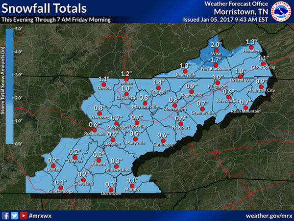
A fast moving clipper will push across the southern Appalachian region late this afternoon through Friday morning. Rain showers will change to snow across Southwest Virginia this evening and snow showers will continue to spread across the area overnight. Snowfall accumulations will be greatest along the Northern Plateau of East Tennessee and the Cumberland mountains of Southwest Virginia where 1 to 3 inches are possible. Elsewhere, up to 1 inch of snow is expected across valley locations, before tapering off around sunrise Friday morning. With surface temperatures below freezing, snow will accumulate on untreated roads. This may result in in negative travel impacts to motorists, especially during the Friday morning commute. (Image courtesy National Weather Service in Morristown)
Note: This story was updated at 11 a.m.
A fast-moving weather system could bring snow to East Tennessee as it pushes across the southern Appalachian region late Thursday afternoon through Friday morning, forecasters said.
Rain showers will change to snow across Southwest Virginia on Thursday evening, and snow showers will continue to spread across the area overnight, according to the National Weather Service in Morristown. Snowfall accumulations will be greatest along the Northern Plateau of East Tennessee and the Cumberland mountains of Southwest Virginia, where one to three inches are possible.
Elsewhere, up to one inch of snow is expected across valley locations, before tapering off around sunrise Friday morning. [Read more…]