• About
    • About Us
    • What We Cover
  • Advertise
    • Advertise
    • Our Advertisers
  • Contact
  • Donate
  • Send News

Oak Ridge Today

  • Home
  • Sign in
  • News
    • Business
    • Community
    • Education
    • Government
    • Health
    • Police and Fire
    • U.S. Department of Energy
    • Weather
  • Sports
    • High School
    • Middle School
    • Recreation
    • Rowing
    • Youth
  • Entertainment
    • Arts
    • Dancing
    • Movies
    • Music
    • Television
    • Theater
  • Premium Content
  • Obituaries
  • Classifieds

ORNL provides building data that helps hurricane response

Posted at 12:28 pm November 4, 2017
By Oak Ridge National Laboratory Leave a Comment

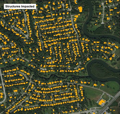
As hurricanes formed in the Gulf Coast, Oak Ridge National Laboratory activated a computing technique to quickly gather building structure data from Texas' coastal counties. (Image credit: Mark Tuttle/Oak Ridge National Laboratory, U.S. Department of Energy)

As hurricanes formed in the Gulf Coast, Oak Ridge National Laboratory activated a computing technique to quickly gather building structure data from Texas’ coastal counties. (Image credit: Mark Tuttle/Oak Ridge National Laboratory, U.S. Department of Energy)


Geospatial scientists at Oak Ridge National Laboratory have developed a new computing technique to quickly gather data about building structures to help emergency response teams assessing properties that were damaged by hurricanes Harvey and Irma in August and September.

By coupling deep learning with high-performance computing, ORNL collected and extracted building outlines and roadways from high-resolution satellite and aerial images, ORNL said. As hurricanes formed in the Gulf Coast and the Atlantic Ocean, ORNL activated its technique.

“During devastating weather events, it’s difficult and time consuming to assess damage manually,” said ORNL’s Mark Tuttle. “Our method supports emergency response efforts by providing preliminary building structure data—which can be categorized for residential, multi-family and commercial properties—on the county level, and this has been applied for hurricane-impacted areas of Texas, Florida, Puerto Rico, and other U.S. Caribbean territories.” [Read more…]

Filed Under: Oak Ridge National Laboratory, U.S. Department of Energy, Weather Tagged With: Benjamin Swan, building structure data, Gulf Coast, Harvey, Hsiuhan Yang, Hurricane Harvey, hurricanes, Irma, Jacob McKee, Mark Tuttle, Matthew Whitehead, Melanie Laverdiere, Oak Ridge National Laboratory, ORNL, Taylor Hauser

ORNL helps emergency responders with hurricanes Harvey, Irma

Posted at 3:37 pm September 7, 2017
By John Huotari Leave a Comment

The map above is part of the LandScan system that has been used by Oak Ridge National Laboratory to help readiness, response, and recovery crews during Hurricane Harvey, which hit most heavily in Texas. This map shows population counts in the Houston area, with red areas having the highest counts and yellow areas lower counts and gray areas none. The map has a flooding overlay, where red is more flooding and green is less. (Photo by John Huotari/Oak Ridge Today)

The map above is part of the LandScan USA system that has been used by Oak Ridge National Laboratory to help readiness, response, and recovery crews during Hurricane Harvey, which hit Texas on Friday, Aug. 25, 2017. This map shows population counts in the Houston area, with red areas having the highest counts and yellow areas lower counts and gray areas none. The map has a flooding overlay, where red shows more flooding and green shows less. (Photo by John Huotari/Oak Ridge Today)


Data collection systems at Oak Ridge National Laboratory are being used to help emergency responders and recovery crews with two deadly hurricanes, Harvey and Irma.

The data collection systems are LandScan USA and EAGLE-I. Information from the systems is being used by the Federal Emergency Management Agency and U.S. Department of Homeland Security, among other agencies. The two systems give information on electric customer outages and population counts, and they are being used in daily briefings, according to ORNL staff members.

The first system, LandScan USA, shows population counts with a resolution of about 90 meters. The system can show color-coded maps with population counts ranging for high to low, and it includes daytime and nighttime populations.

Flood maps can be overlaid on the population count maps to help determine the best places for rescuers to respond, said Amy Rose, ORNL team lead in Population Distribution and Dynamics. Rose displayed that map and overlay during an interview in the EVEREST visualization laboratory at ORNL on Tuesday.

Houston, which experienced heavy flooding, didn’t evacuate before Hurricane Harvey, a category 4 storm that came ashore just northeast of Corpus Christi, Texas, on Friday night, August 25. [Read more…]

Filed Under: Front Page News, Oak Ridge National Laboratory, ORNL, Slider, U.S. Department of Energy, Weather Tagged With: Amy Rose, data collection systems, EAGLE-I, emergency responders, Federal Emergency Management Agency, FEMA, Houston, Hurricane Harvey, Hurricane Irma, Jibonananda "Jibo" Sanyal, LandScan USA, Oak Ridge National Laboratory, ORNL, Puerto Rico, recovery crews, Rick Lusk, Texas, Texas A&M University, U.S. Department of Homeland Security, Unmanned Aerial Systems Surveillance and Research Center

Search Oak Ridge Today

Classifieds

Availability of the draft environmental assessment for off-site depleted uranium manufacturing (DOE/EA-2252)

The U.S. Department of Energy (DOE) National Nuclear Security Administration (NNSA) announces the … [Read More...]

Public Notice: NNSA announces no significant impact of Y-12 Development Organization operations at Horizon Center

AVAILABILITY OF THE FINAL ENVIRONMENTAL ASSESSMENT FOR THE OFFSITE HOUSING OF THE Y-12 DEVELOPMENT … [Read More...]

ADFAC seeks contractors for five homes

Aid to Distressed Families of Appalachian Counties (ADFAC) is a non-profit community based agency, … [Read More...]

Recent Posts

  • Author and Law Professor Derek W. Black to Speak on Public Education and Democracy
  • Anderson County Chamber Headquarters Dedication Set for October 17
  • ORISE announces winners of 2025 Future of Science Awards
  • SL Tennessee Supports New Anderson County Chamber Headquarters
  • ORAU 2025 Pollard Scholarship recipients announced
  • Democratic Womens Club Hosts State Rep. Sam McKenzie
  • Flatwater Tales Storytelling Festival Announces 2025 Storytellers
  • Laser-Engraved Bricks Will Line Walkway of New Chamber Headquarters
  • Democratic Womens Club to Discuss Climate Change, Energy and Policy
  • Estate Jewelry Show at Karens Jewelers Features Celebrity Jewelry

Recent Comments

  • Raymond Mitchell on City manager’s ‘State of the City’ canceled due to weather
  • Raymond Mitchell on City manager’s ‘State of the City’ canceled due to weather
  • Mysti M Desilva on Crews clearing roads, repairing water line breaks
  • Mel Schuster on Crews clearing roads, repairing water line breaks
  • Cecil King on Crews clearing roads, repairing water line breaks
  • Rick Morrow on Roads, schools, businesses closed after heavy snow
  • Diana lively on Free community Thanksgiving Dinner on Nov. 25
  • Anne Garcia on School bus driver arrested following alleged assault on elementary student
  • Raymond Dickover on Blockhouse Valley Recycling Center now open 6 days per week
  • Mike Mahathy on School bus driver arrested following alleged assault on elementary student

Copyright © 2025 Oak Ridge Today