
An Oak Ridge snow plow is pictured above at center on Oak Ridge Turnpike, which was mostly clear on Tuesday evening, February 17.
Crews from the Oak Ridge Public Works Department had treated all 230 miles of streets by the time they left work on Thursday, and they’re now battling a half-dozen small water main breaks.
Oak Ridge Public Works Director Gary Cinder said crews focused on what are known as Level 3 and Level 4 streets on Thursday. They removed all loose snow. But there could still be patches of ice on some roads, Cinder said.
“You can’t get ice off the street until you get much warmer temperatures,” he said.
Crews are back out this morning “hitting the parts that needed treatment,” Cinder said.
He continued to urge caution for those who are driving.
“You’ve got to drive like it’s winter,” he said.
Cinder said there was a lot more traffic on the roads this morning. Some offices and employers like the Anderson County Courthouse and Y-12 National Security Complex that had been closed all week re-opened on Friday.
Some residents had raised questions about the main roads being clear while some side streets remained impassable.
Cinder said the city “continues to ask for people’s patience” as crews respond to the unusual weather this week, which included icy precipitation on Monday and snow on Wednesday, followed by bitter cold on Thursday and Friday. He was scheduled to participate in a weather forecast webinar with the National Weather Service at noon Friday and said he should have more information on what’s in store for Friday night and Saturday after that.
Cinder said there could be warming and rain by lunchtime Saturday, and the earlier estimates of snowfall that had been forecast for the Knoxville area appear to have been reduced, with warmer temperatures coming through sooner than expected.
Rain should start melting everything, he said.
“The challenge now is water main breaks,” Cinder said. “The crews are out on that right now.”
When the temperatures plummet and then bounce back up, old cast-iron pipes in the city will break.
There were six water main breaks on the east end of town just before noon Friday (an earlier break had been repaired). Cinder said they were all small mains and have been easy to get at so far.
The breaks were at Arkansas Avenue at Oak Ridge Turnpike, on West Tyrone Road, Wayside Road, Lehigh Lane, Delaware Avenue, and East Tennessee Avenue at Georgia Avenue. The last break isn’t bad, Cinder said, and the city is letting the water run into a storm drain for now. Fixing the break would require shutting off the water main to Jackson Square, which could affect businesses already hurt by the winter weather this week.
Crews will repair that break once the Jackson Square businesses close for the evening, unless it “blows out” before then, Cinder said.
“Right now, it’s manageable,” he said.
A winter storm warning has been issued for Anderson, Campbell, Knox, and Loudon counties, among a few others, from 7 p.m. Friday to 1 p.m. Saturday. Affected cities include Oak Ridge, Clinton, Lenoir City, and Knoxville.
Precipitation will start as snow this afternoon and evening, then switch to freezing rain/sleet overnight, then to all rain by Saturday morning/afternoon.
Here was the forecast near Oak Ridge as of about 12:30 p.m. Friday:
Friday afternoon: A 30 percent chance of snow, mainly after 4 p.m. Cloudy, with a high near 28. South wind around 5 mph.
Friday night: A chance of snow before 10 p.m., then freezing rain and sleet likely between 10 p.m. and 1 a.m., then freezing rain after 1 a.m. Low around 25. Light and variable wind becoming south 5 to 10 mph in the evening. Chance of precipitation is 90 percent. New ice accumulation of 0.1 to 0.3 of an inch possible. New snow and sleet accumulation of around an inch possible.
Saturday: Freezing rain before 1 p.m., then rain. High near 44. South wind around 15 mph, with gusts as high as 25 mph. Chance of precipitation is 80 percent. New ice accumulation of less than a 0.1 of an inch possible.
Saturday night: Rain. Low around 38. South wind 5 to 15 mph becoming north after midnight. Winds could gust as high as 20 mph. Chance of precipitation is 90 percent.
There is a slight chance of snow again on Monday and Tuesday.
“Rapid snow and/or ice accumulations make hazardous conditions possible late Friday night into Saturday morning,” the NWS said.
More information will be added as it becomes available.
See the city’s Winter Weather Plan here. It includes definitions of Level 3 and Level 4 streets.
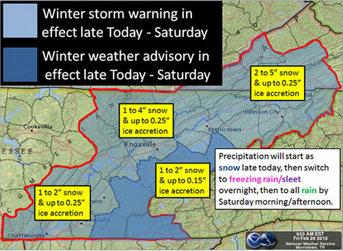
Image courtesy National Weather Service in Morristown
Copyright 2015 Oak Ridge Today. All rights reserved. This material may not be published, broadcast, rewritten, or redistributed.


Jason Allison says
What would have been nice is for the plow trucks to actually use the plows instead of just salting the roads. They came up my street well before the ice and there was quite a bit of accumulated precipitation that never saw a blade.
johnhuotari says
Jason,
If you have a concern about an Oak Ridge city street that needs attention, I think you can call 425-1875 during the day.
I hope that helps.
Thank you,
John