
The map above is part of the LandScan USA system that has been used by Oak Ridge National Laboratory to help readiness, response, and recovery crews during Hurricane Harvey, which hit Texas on Friday, Aug. 25, 2017. This map shows population counts in the Houston area, with red areas having the highest counts and yellow areas lower counts and gray areas none. The map has a flooding overlay, where red shows more flooding and green shows less. (Photo by John Huotari/Oak Ridge Today)
Data collection systems at Oak Ridge National Laboratory are being used to help emergency responders and recovery crews with two deadly hurricanes, Harvey and Irma.
The data collection systems are LandScan USA and EAGLE-I. Information from the systems is being used by the Federal Emergency Management Agency and U.S. Department of Homeland Security, among other agencies. The two systems give information on electric customer outages and population counts, and they are being used in daily briefings, according to ORNL staff members.
The first system, LandScan USA, shows population counts with a resolution of about 90 meters. The system can show color-coded maps with population counts ranging for high to low, and it includes daytime and nighttime populations.
Flood maps can be overlaid on the population count maps to help determine the best places for rescuers to respond, said Amy Rose, ORNL team lead in Population Distribution and Dynamics. Rose displayed that map and overlay during an interview in the EVEREST visualization laboratory at ORNL on Tuesday.
Houston, which experienced heavy flooding, didn’t evacuate before Hurricane Harvey, a category 4 storm that came ashore just northeast of Corpus Christi, Texas, on Friday night, August 25.
LandScan USA collects population distribution data from U.S. census figures and high-resolution satellite images. It also incorporates data from the American Community Survey and information on places like prisons, hospitals, nursing homes, daycares, and schools, providing estimates of how many people might be at the facilities and where they are located. LandScan USA also includes business locations and employment numbers.
Providing additional information on structures, ORNL has taught a machine to take high-resolution imagery of buildings and draw boxes around them, helping to determine the number of structures that could be affected by a storm or other hazard or disaster. The information is useful because, among other things, structures can sometimes be hidden by flooding.
ORNL will be involved with Hurricane Harvey for a while, Rose said.
“It’s going to be a long recovery,” she said.
On Tuesday, ORNL staff were preparing for the arrival of Hurricane Irma. That hurricane, now a Category 5, was headed west from the Atlantic Ocean, and it has since devastated northern Caribbean islands and could hit Florida, possibly by early Sunday.
Besides being useful for regions affected by extreme weather events and other disasters, LandScan USA is also helpful for determining the scale of the damage and for recovery efforts.
ORNL has helped with other earlier disasters, including Hurricane Katrina, flooding in California, global fires, ebola in West Africa, tsunamis in Japan and the Indian Ocean, and earthquakes in Nepal and Pakistan.
Some of the ORNL work can be used for natural disaster emergency preparedness.
“Understanding the distribution of people really helps,” Rose said.
On Thursday, Rose said ORNL has already provided information to the Department of Homeland Security and FEMA for Puerto Rico and the U.S. Virgin Islands and started providing some on Thursday for Florida. Later, the lab will provide information for Georgia and South Carolina.
The other system, an interactive web-tool known as EAGLE-I (pronounced Eagle-EYE), is supporting emergency response teams in the Gulf Coast region by locating critical energy infrastructure affected by Harvey.
Like LandScan USA, EAGLE-I is also being used for Hurricane Irma, one of the most powerful Atlantic hurricanes ever.
On Tuesday, Jibonananda “Jibo” Sanyal, a staff scientist and ORNL team lead in scalable and high-performance geocomputation, said the EAGLE-I system is updated every 15 minutes, and it can be used to help determine the number of customers without power and give a consolidated picture of a region.
“We have this data down to the county level,” Sanyal said.
At one point during Hurricane Harvey, there were more than 320,000 customers without power in the region, Sanyal said. On Tuesday, there were 3,658 customers out of about 1,856,263, or 0.20 percent, in Harris County, Texas, according to an EAGLE-I map.
“That basically means a good amount of customers have been restored, and recovery operations are working well,” Sanyal said.

Amy Rose
He said a coordinated response is needed for disasters, and EAGLE-I data can be used by FEMA and other emergency responders to help determine how they want to go about their planning. Those agencies have other inputs as well, Sanyal said.
The system is operated at ORNL, and emergency operation centers use it in their daily briefings, Sanyal said. It gives agencies such as FEMA and state and local responders “the means to plan, react, respond, and aid recovery and restoration efforts efficiently,” ORNL said.
Sanyal said there are 3,200 electric utilities across the United States, and about 84 percent of all utility customers are in the EAGLE-I system in the U.S.
ORNL has received feedback that the service has been invaluable, including for fighting fires in Colorado. Besides hurricanes and fires, EAGLE-I can be used for other hazards, such as droughts.
ORNL has been in touch with other agencies through FEMA, and the lab expects to receive more requests for data, Sanyal said.
On Thursday, Sanyal said ORNL had released a special report for Puerto Rico that will be updated every 15 minutes.
“We are just helping out people who need data,” Sanyal said.

Jibonananda “Jibo” Sanyal
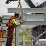
Also related to Hurricane Harvey, ORNL and Texas A&M University-Corpus Christi are providing drone expertise to help survey damage from Harvey in Rockport, Texas, where the hurricane came ashore.
Those involved are the Lone Star UAS Center of Excellence and Innovation, or LSUASC, at Texas A&M University-Corpus Christi and Rick Lusk, director of the Unmanned Aerial Systems Surveillance and Research Center at ORNL, a U.S. Department of Energy laboratory. They are conducting imaging and survey missions across the City of Rockport.
Rockport, located 30 minutes north of Corpus Christi, sustained almost 60 percent destruction to its buildings after Hurricane Harvey’s landfall one week ago, according to Texas A&M University-Corpus Christi.
Jerry Hendrix, director of the LSUASC, and Lusk set out to conduct power line inspections using rotary craft UAS (unmanned aerial systems) near Holiday Beach, a small bayfront community located eight miles north of Rockport at the request of Aransas County Judge Burt Mills, Texas A&M said.
They were helped by Jaime McAlister, a captain of the Rockport Volunteer Fire Department and self-proclaimed drone enthusiast.
You can see the full Texas A&M University story here.
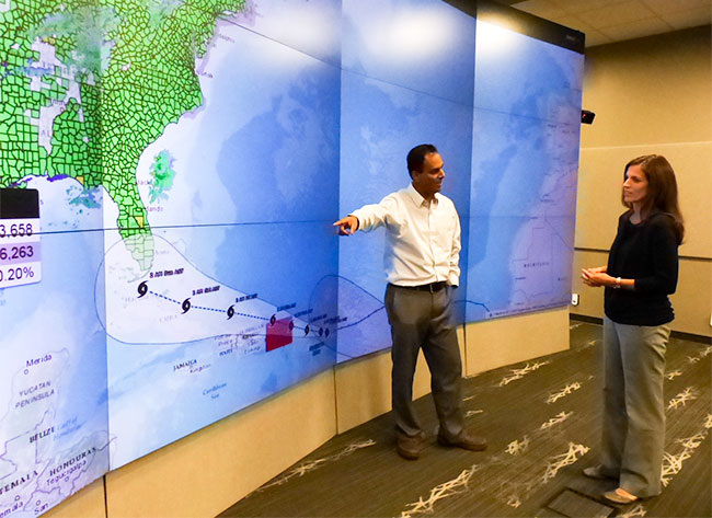
Jibonananda “Jibo” Sanyal, left, and Amy Rose of Oak Ridge National Laboratory discuss the lab’s help with data on electric power outages and population counts in hazards and emergencies such as Hurricane Harvey in Texas and Hurricane Irma, approaching from the Atlantic Ocean above, as pictured on Tuesday, Sept. 5, 2017. (Photo by John Huotari/Oak Ridge Today)
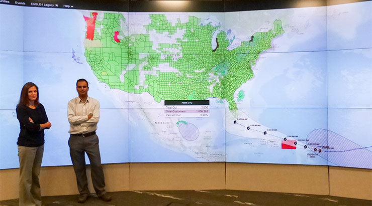
Jibonananda “Jibo” Sanyal, right, and Amy Rose of Oak Ridge National Laboratory discuss the lab’s help with data on electric power outages and population counts in hazards and emergencies such as Hurricane Harvey in Texas and Hurricane Irma, approaching from the Atlantic Ocean above, as pictured on Tuesday, Sept. 5, 2017. The map above shows ORNL’s EAGLE-I system, and it includes information on the remaining power outages in Harris County, Texas. (Photo by John Huotari/Oak Ridge Today)
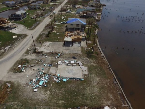
Oak Ridge National Laboratory is working with Texas A&M University-Corpus Christi to use drones to conduct imaging and survey missions across the City of Rockport, Texas, after Hurricane Harvey in late August 2017. (Picture courtesy ORNL on Twitter via Texas A&M University-Corpus Christi)
More information will be added as it becomes available.
Do you appreciate this story or our work in general? If so, please consider a monthly subscription to Oak Ridge Today. See our Subscribe page here. Thank you for reading Oak Ridge Today.
Copyright 2017 Oak Ridge Today. All rights reserved. This material may not be published, broadcast, rewritten, or redistributed.


Leave a Reply