
Snow and cold temperatures are likely in Oak Ridge on Thursday, the National Weather Service in Morristown said, and many schools in the area, including in Oak Ridge, are closed.
Here is the NWS forecast for the Oak Ridge area on Thursday, when the high is expected to be 36 degrees Fahrenheit, with a mostly cloudy sky and a wintry mix of precipitation:
- Rain, snow, and sleet before 4 p.m. Thursday.
- Rain between 4 and 5 p.m.
- Rain and snow after 5 p.m.
The chance of precipitation is 100%, but the Weather Service does not expect much snow or sleet to accumulate. The NWS said it has “moderate confidence in the start time for snow since minor changes in temperature can affect when rain turns to snow.”
But this evening, there could be one to two inches of snow that accumulate, the NWS said. Snow is likely mainly before 8 p.m., the forecast said. The chance of precipitation is 60%.
More snow, up to 4 inches, is possible at higher elevations.
The low tonight in the Oak Ridge area is forecast at 15.
“In addition to the snow, please be prepared for the low temperatures tonight and again on Friday night,” the NWS said. “This will be the coldest air of the season! Also, wind chill values will range from just below zero to the single digits for most areas on Friday morning.”
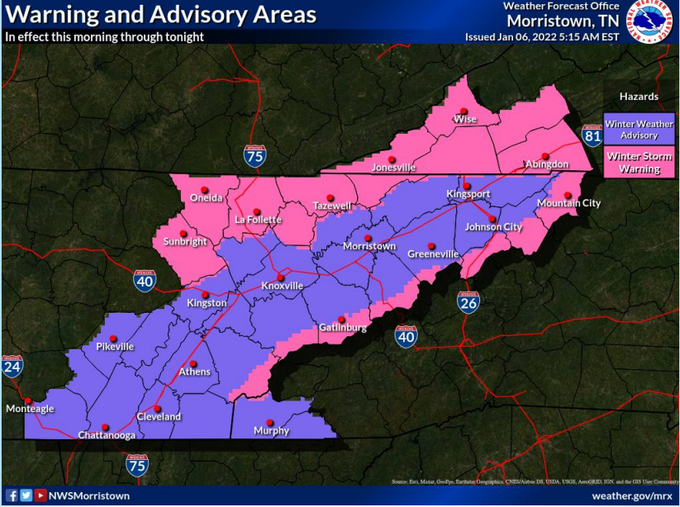
A winter weather advisory is in effect from noon Thursday to 7 a.m. Friday.
“Plan on slippery road conditions,” the NWS said. “The hazardous conditions could impact the morning or evening commute. … Slow down and use caution while traveling.”
The NWS said you can call 511 to get the latest road conditions for your state.
Besides schools, state offices across Tennessee are also closed Thursday due to the expected hazardous weather and travel conditions, including freezing rain, ice, and snow. State services that are offered online will remain available, a press release said.
Friday and Friday night are forecast to be mostly sunny and mostly clear. The cold, freezing conditions will continue, with the high on Friday near 31 and a low on Friday night around 17.
Temperatures are forecast to warm to above freezing on Saturday, with a high near 44 and a low around 34. There is a chance of rain and snow showers early Sunday.
Here is the NWS hazardous weather outlook for parts of southwest North Carolina, East Tennessee, and southwest Virginia:
.DAY ONE...Today and Tonight

A winter weather system will affect the region today and tonight,
with snowfall accumulations expected. A Winter Storm Warning has
been issued for the northern Cumberland Plateau, southwest
Virginia, and the mountains of East Tennessee. A Winter Weather
Advisory has been issued for the rest of the East Tennessee
Valley.

The highest snowfall totals are expected along the northern
Cumberland Plateau into Southwest Virginia, with 3 to 6 inches
possible. The southern Appalachian Mountains could see snowfall
totals of 3 to 7 inches, with the heaviest amounts at the tops of
the mountains. In the Valley, snowfall totals from a dusting up
to around 3 inches are possible, with lower amounts in southeast
Tennesee and the higher amounts in northeast Tennessee.

A mix of freezing rain, sleet, and snow will be possible for
the higher elevation areas of the southern Cumberland Plateau and
southwest North Carolina today.

Temperatures on Friday morning will drop into the teens to single
digits, and wind chill values may drop below 0 in the higher
elevations before sunrise.

.DAYS TWO THROUGH SEVEN...Friday through Wednesday

No hazardous weather is expected at this time.
More information will be added as it becomes available.
Most news stories on Oak Ridge Today are free, brought to you by Oak Ridge Today with help from our advertisers, contributors, and subscribers. This is a free story. Thank you to our advertisers, contributors, and subscribers. You can see what we cover here.
Do you appreciate this story or our work in general? If so, please consider a monthly subscription to Oak Ridge Today. See our Subscribe page here. Thank you for reading Oak Ridge Today!
Alternatively, you can donate to support our work here. Thank you for your support!
Copyright 2021 Oak Ridge Today. All rights reserved. This material may not be published, broadcast, rewritten, or redistributed.
Leave a Reply