• About
    • About Us
    • What We Cover
  • Advertise
    • Advertise
    • Our Advertisers
  • Contact
  • Donate
  • Send News

Oak Ridge Today

  • Home
  • Sign in
  • News
    • Business
    • Community
    • Education
    • Government
    • Health
    • Police and Fire
    • U.S. Department of Energy
    • Weather
  • Sports
    • High School
    • Middle School
    • Recreation
    • Rowing
    • Youth
  • Entertainment
    • Arts
    • Dancing
    • Movies
    • Music
    • Television
    • Theater
  • Premium Content
  • Obituaries
  • Classifieds

Snow, bitter cold from Sunday night through Tuesday; some schools closed

Posted at 6:39 pm January 5, 2014
By John Huotari Leave a Comment

East Tennessee Winter Weather

Images courtesy of National Weather Service in Morristown.

Weather forecasters are calling for snow and bitterly cold conditions across the region from Sunday night through Tuesday, and they said Monday night could be the coldest night in more than 10 years.

The National Weather Service in Morristown said a cold front will approach the area Sunday night, and rain will transition to snow in the late evening, with arctic air moving in behind the front.

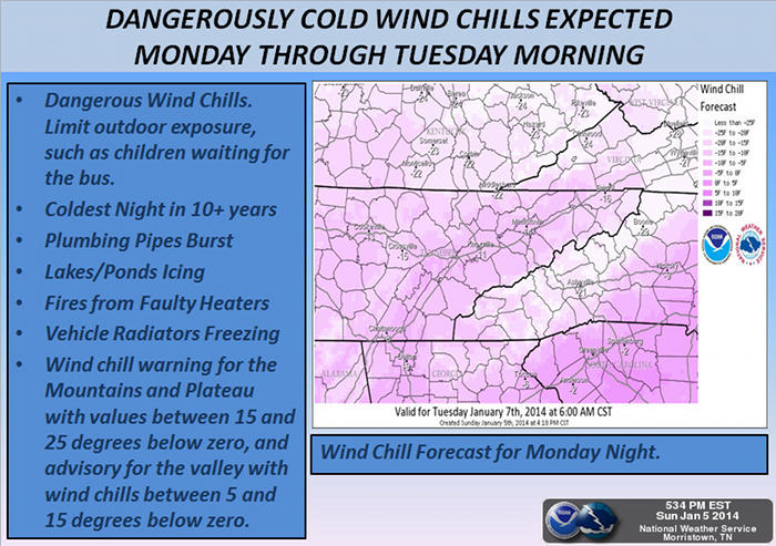
Low temperatures from Monday night into Tuesday will range from -6 degrees Fahrenheit to around 5 degrees across the region. Dangerously cold wind chills are expected Monday through Tuesday morning. Wind chills will drop to 15 to 25 degrees below zero across the plateau and mountains, and between 5 and 15 degrees below zero over the valley.

Dangerously Cold Wind Chills

The Weather Service recommends limiting outdoor exposure, including for children waiting for schools buses. Some schools have already announced they’re closed Monday, including in Roane County. Students in Oak Ridge Schools don’t return to classes until Tuesday.

Forecasters said snow accumulations Sunday night and Monday morning will vary from 0.5 to 1.5 inches across most of the area through Monday morning. There will be greater snowfall across the higher elevations, where two to five inches are expected.

The forecast near Oak Ridge calls for a 100 percent chance of rain or snow on Sunday night, with a low around 18 and a 30 percent chance of snow on Monday. Wind chill values on Monday are expected to be between -1 and 7, falling to between -3 and -12 on Monday night as winds gust as high as 25 mph.

Tuesday is forecast to be sunny and cold, with a high near 17 and wind chill values between -2 and -12.

Temperatures are expected to climb later in the week, with a high of 37 on Wednesday.

Filed Under: Education, K-12, Slider, Top Stories, Weather, Weather Tagged With: cold, cold front, forecast, Morristown, National Weather Service, Oak Ridge Schools, Roane County, schools, snow, temperatures, wind chill

Leave a Reply Cancel reply

Your email address will not be published. Required fields are marked *

Recent Posts

  • Author and Law Professor Derek W. Black to Speak on Public Education and Democracy
  • Anderson County Chamber Headquarters Dedication Set for October 17
  • ORISE announces winners of 2025 Future of Science Awards
  • SL Tennessee Supports New Anderson County Chamber Headquarters
  • ORAU 2025 Pollard Scholarship recipients announced
  • Democratic Women’s Club Hosts State Rep. Sam McKenzie
  • Flatwater Tales Storytelling Festival Announces 2025 Storytellers
  • Laser-Engraved Bricks Will Line Walkway of New Chamber Headquarters
  • Democratic Women’s Club to Discuss Climate Change, Energy and Policy
  • Estate Jewelry Show at Karen’s Jewelers Features Celebrity Jewelry

Search Oak Ridge Today

Copyright © 2025 Oak Ridge Today