
Road crews on Friday prepared roads for possible winter weather, including a potential snow, on Saturday, March 11, 2017. This picture was taken on Wisconsin Avenue on Friday afternoon, March 10. (Photo by Julio Culiat)
On Friday, crews prepared roads for possible winter weather this weekend in Oak Ridge and East Tennessee, potentially including snow on Saturday.
The National Weather Service in Morristown said winter will return this weekend with snowfall expected Saturday night across most of the region. Snow accumulations of one to three inches are possible across the Tennessee Valley and Cumberland Plateau, and three to six inches are possible in the Great Smoky Mountains.
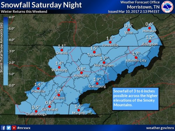
Winter returns this weekend with snowfall expected Saturday night, March 11, 2017, across most of the region. Snow accumulations of 1 to 3 inches across the Valley and Plateau to 3 to 6 inches possible across the Smoky Mountains. Please stay tuned to the latest weather forecast. (Image courtesy National Weather Service in Morristown)
A freeze warning is in effect from 1 a.m. to 9 a.m. Saturday, March 11. A freeze watch is in effect from 12 a.m. to 10 a.m. Sunday, March 12.
The freeze warning is in effect for most of the area on Friday night and Saturday morning, except for far southeast Tennessee, the National Weather Service said.
The widespread snowfall is expected Saturday night into Sunday morning, with much colder air anticipated over the weekend into next week, possibly through Thursday.
“Winter will return this weekend,” the National Weather Service said. “Snow accumulations of one to three inches in the Valley to three to six inches across the far eastern Tennessee Mountains. Travel conditions may deteriorate Saturday night and early Sunday morning, especially across the higher elevations, secondary roads, and bridges and overpasses. Temperatures should warm enough Sunday to alleviate most travel issues by afternoon.
“In addition, much colder temperatures are expected next week with morning lows in the 20s most mornings with teens possible in northeast Tennesse and Southwest Virginia. A chance of accumulating snowfall again Monday night through Tuesday night in the higher elevations. Freeze watch is in effect for most of the area Saturday night and Sunday morning, except for far southeast Tennessee.”
See the National Weather Service website here.
See the hazardous weather outlook here.
See a special weather statement here.
More information will be added as it becomes available.
Do you appreciate this story or our work in general? If so, please consider a monthly subscription to Oak Ridge Today. See our Subscribe page here. Thank you for reading Oak Ridge Today.
Copyright 2016 Oak Ridge Today. All rights reserved. This material may not be published, broadcast, rewritten, or redistributed.


Leave a Reply