• About
    • About Us
    • What We Cover
  • Advertise
    • Advertise
    • Our Advertisers
  • Contact
  • Donate
  • Send News

Oak Ridge Today

  • Home
  • Sign in
  • News
    • Business
    • Community
    • Education
    • Government
    • Health
    • Police and Fire
    • U.S. Department of Energy
    • Weather
  • Sports
    • High School
    • Middle School
    • Recreation
    • Rowing
    • Youth
  • Entertainment
    • Arts
    • Dancing
    • Movies
    • Music
    • Television
    • Theater
  • Premium Content
  • Obituaries
  • Classifieds

Snow possible Wednesday morning; winter weather advisory in East Tennessee

Posted at 8:56 pm January 14, 2014
By John Huotari Leave a Comment

Winter Weather Advisory

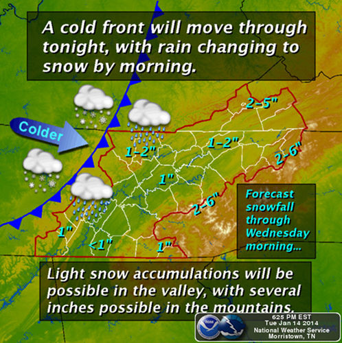
Image courtesy National Weather Service in Morristown.

Snow is possible Wednesday morning as a cold front moves through East Tennessee.

Light snow accumulations are possible in the valley, with several inches possible in the mountains, according to the National Weather Service in Morristown.

Forecasters said the winter storm is moving into the area from the plains late tonight, and rain is expected to change to snow within the first few hours. By rush hour Wednesday morning, much of the area will be receiving light to moderate snow, the Weather Service said.

“The system will slowly exit the area to the east, with snows lingering in the mountains into Wednesday night,” the NWS said.

The winter weather advisory is in effect from midnight Tuesday to 6 p.m. Wednesday. It applies to Anderson, Knox, Loudon, Morgan, Roane, Scott, and Union counties, among others.

The advisory said rain showers will quickly change to snow showers late tonight, and snow totals of one to two inches are expected. The winter weather could start after midnight and taper off Wednesday afternoon.

Travel on some roads could be hazardous, the advisory said.

The forecast near Oak Ridge calls for a 100 percent chance of rain or snow Tuesday night, with a low of 33, and an 80 percent chance of snow on Wednesday. There is also a 30 percent chance of snow on Thursday night and Friday.

Filed Under: Slider, Top Stories, Weather, Weather Tagged With: cold front, East Tennessee, National Weather Service, NWS, Oak Ridge, snow, winter storm, winter weather advisory

Leave a Reply Cancel reply

Your email address will not be published. Required fields are marked *

Recent Posts

  • Anderson County Chamber Headquarters Dedication Set for October 17
  • ORISE announces winners of 2025 Future of Science Awards
  • SL Tennessee Supports New Anderson County Chamber Headquarters
  • ORAU 2025 Pollard Scholarship recipients announced
  • Democratic Womens Club Hosts State Rep. Sam McKenzie
  • Flatwater Tales Storytelling Festival Announces 2025 Storytellers
  • Laser-Engraved Bricks Will Line Walkway of New Chamber Headquarters
  • Democratic Womens Club to Discuss Climate Change, Energy and Policy
  • Estate Jewelry Show at Karens Jewelers Features Celebrity Jewelry
  • Keri Cagle named new ORAU senior vice president and ORISE director

Search Oak Ridge Today

Copyright © 2025 Oak Ridge Today