The National Weather Service says a strong regional storm system could bring heavy rain, sleet, and snow early this week. (Images courtesy National Weather Service)
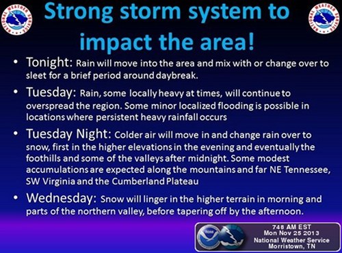
The National Weather Service in Morristown is warning of a strong regional storm system that could bring heavy rain, sleet, and snow to East Tennessee and southwest Virginia early this week.
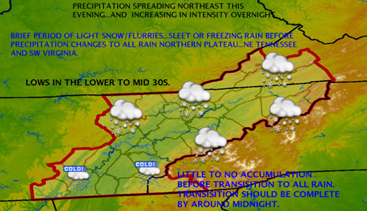
Forecasters said rain will move into the area tonight (Monday night) and could briefly change over to or mix with sleet around daybreak Tuesday. The rain is expected to continue Tuesday, with some minor local flooding possible.
Colder air moving into the region on Tuesday night could change the rain to snow, starting at higher elevations in the evening and working down to the foothills and some valleys after midnight, forecasters said.
Some modest snow accumulations are expected along the mountains and far northeastern Tennessee, southwest Virginia, and the Cumberland Plateau, the Weather Service said.
Snow will linger at higher elevations on Wednesday morning and parts of the northern valley, before tapering off by the afternoon.
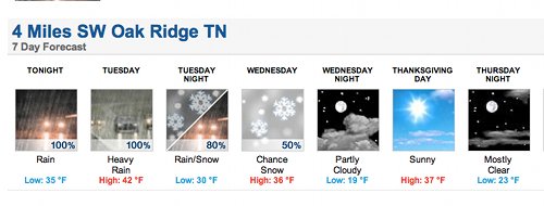
The forecast near Oak Ridge calls for rain tonight (Monday night) with a low of 35, heavy rain on Tuesday with a high of 42, an 80 percent chance of rain or snow on Tuesday night with a low of 30, and a 50 percent chance of snow on Wednesday, when the high is expected to be 36.
The Weather Service is calling for a low of 19 on a partly cloudy Wednesday night and a sunny Thanksgiving Day.
Leave a Reply